Search results
From XMS Wiki
Jump to navigationJump to search
Page title matches
File:ArcGIS Pro Rasters to GeoSections.png The ''Rasters to Geosections'' tool in the ''Geoprocessing'' pane in ArcGIS Pro.(368 × 498 (21 KB)) - 16:01, 16 August 2022
File:ArcGIS Pro Rasters to GeoVolumes.png The ''Rasters to GeoVolumes'' tool in the ''Geoprocessing'' pane in ArcGIS Pro.(406 × 497 (22 KB)) - 17:25, 16 August 2022
File:AHGW Subsurface Analyst Features - Rasters to GeoSections.png The [[AHGW:Rasters to GeoSections|''Rasters to GeoSections'' dialog]] in [[AHGW:AHGW|Arc Hydro Groundwater]].(486 × 438 (34 KB)) - 00:03, 29 August 2019
File:AHGW Subsurface Analyst Features - Rasters to GeoVolumes.png The [[AHGW:Rasters to GeoVolumes|''Rasters to GeoVolumes'' dialog]] in [[AHGW:AHGW|Arc Hydro Groundwater]].(486 × 440 (32 KB)) - 00:11, 29 August 2019


Page text matches
File:AHGW Subsurface Analyst Features - Rasters to GeoSections.png The [[AHGW:Rasters to GeoSections|''Rasters to GeoSections'' dialog]] in [[AHGW:AHGW|Arc Hydro Groundwater]].(486 × 438 (34 KB)) - 00:03, 29 August 2019File:AHGW Subsurface Analyst Features - Rasters to GeoVolumes.png The [[AHGW:Rasters to GeoVolumes|''Rasters to GeoVolumes'' dialog]] in [[AHGW:AHGW|Arc Hydro Groundwater]].(486 × 440 (32 KB)) - 00:11, 29 August 2019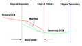
File:Blend Raster to Edges.png [[Category:Toolbox Rasters]](854 × 482 (25 KB)) - 17:28, 26 October 2023
File:Datasets to Rasters.png The Dataset to Rasters dialog(747 × 757 (49 KB)) - 18:52, 20 September 2021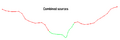
File:Combined Sources.png [[Category:Toolbox Rasters]](953 × 314 (11 KB)) - 18:46, 26 October 2023
File:Trimrastertool2.png [[Category:Toolbox Rasters]](1,019 × 870 (298 KB)) - 19:44, 26 October 2023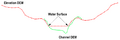
File:Channel to Clip.png [[Category:Toolbox Rasters]](945 × 318 (17 KB)) - 18:46, 26 October 2023
File:Trimrastertool1.png [[Category:Toolbox Rasters]](1,776 × 1,132 (1.04 MB)) - 19:44, 26 October 2023
File:BoundstoPolygon1.png [[Category:Toolbox Rasters]](419 × 530 (187 KB)) - 18:30, 26 October 2023
File:ExtendtoPolygon2.png [[Category:Toolbox Rasters]](576 × 409 (115 KB)) - 19:03, 26 October 2023
File:Nodatatopolygon2.jpg [[Category:Toolbox Rasters]](376 × 432 (11 KB)) - 19:12, 26 October 2023
File:Nodatatopolygon1.jpg [[Category:Toolbox Rasters]](438 × 480 (10 KB)) - 19:12, 26 October 2023
File:ExtendtoPolygon1.png [[Category:Toolbox Rasters]](576 × 409 (19 KB)) - 19:03, 26 October 2023File:ArcGIS Pro Rasters to GeoSections.png The ''Rasters to Geosections'' tool in the ''Geoprocessing'' pane in ArcGIS Pro.(368 × 498 (21 KB)) - 16:01, 16 August 2022File:ArcGIS Pro Rasters to GeoVolumes.png The ''Rasters to GeoVolumes'' tool in the ''Geoprocessing'' pane in ArcGIS Pro.(406 × 497 (22 KB)) - 17:25, 16 August 2022
File:BoundstoPolygon2.png [[Category:Toolbox Rasters]](421 × 535 (187 KB)) - 18:31, 26 October 2023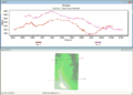
File:ProfilePlotRaster.png Data that has been plotted from the rasters in the selected raster set.(800 × 570 (145 KB)) - 18:42, 22 February 2017


