WMS:HEC-HMS Standard Project Storm
"The standard project storm method can be used to compute precipitation for estimating the standard project flood (Corps of Engineers, 1952). The method is appropriate for watersheds in the United States east of 105° west longitude with an area less than 1,000 square miles. New methods in risk-based analysis have generally replaced the standard project flood criteria." (HEC-HMS User's Manual)
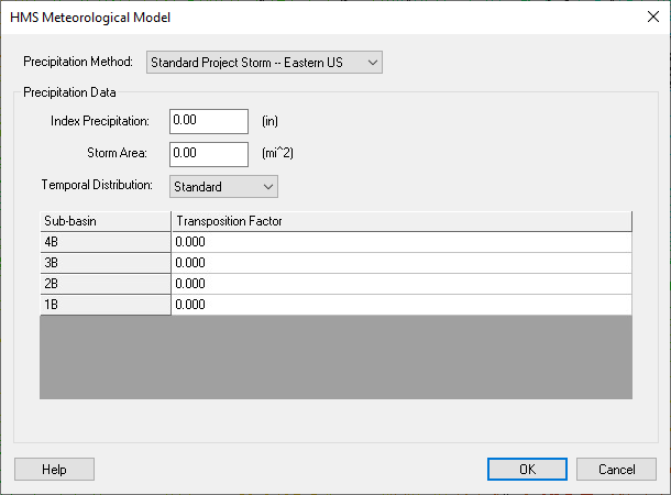
The HMS Meteorological Model dialog for the Standard Project Storm method is shown below:
You can get the index precipitation value (also known as the probable maximum index precipitation) from HYDROMET Report 33. It can also be estimated from plates contained in EM 1110-2-1411 (US Army Corps of Engineers) and represents the total precipitation depth for the storm. The storm area is the total drainage area at the point where the standard project flood is to be estimated. For the temporal distribution type, the standard storm distributes the precipitation according to the criteria outlined in EM 1110-2-1411. The "SWD" option distributes precipitation according to the Southwestern Division criteria (table 3.1 of the HEC-1 reference manual).
Each basin requires a transposition factor. The transposition factor for each subbasin can range from 0.80 to 1.40 and is multiplied by the index precipitation to determine the mean areal precipitation. The transposition factor can be determined from the SPS isohyetal pattern contained in EM 1110-2-1411 and a map of the watershed.
Reference: USACE (1952) Standard project flood determinations. EM 1110-2-1411. Washington, DC.
Related Topics:
WMS – Watershed Modeling System | ||
|---|---|---|
| Modules: | Terrain Data • Drainage • Map • Hydrologic Modeling • River • GIS • 2D Grid • 2D Scatter |  |
| Models: | CE-QUAL-W2 • GSSHA • HEC-1 • HEC-HMS • HEC-RAS • HSPF • MODRAT • NSS • OC Hydrograph • OC Rational • Rational • River Tools • Storm Drain • SMPDBK • SWMM • TR-20 • TR-55 | |
| Toolbars: | Modules • Macros • Units • Digitize • Static Tools • Dynamic Tools • Drawing • Get Data Tools | |
| Aquaveo | ||
