AHGW:Groundwater Analyst: Difference between revisions
From XMS Wiki
Jump to navigationJump to search
No edit summary |
No edit summary |
||
| Line 1: | Line 1: | ||
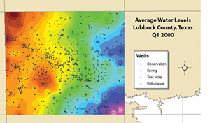
[[File:AHGW Groundwater Analyst example.png|thumb|right|An example of using the groundwater analyst]] | [[File:AHGW Groundwater Analyst example.png|thumb|right|An example of using the groundwater analyst]] | ||
Tools in the Groundwater Analyst allows importing of data into an [[AHGW:AHGW|Arc Hydro Groundwater]] (AHGW) data model, managing key attributes, and visualizing the data. Groundwater Analyst facilitates importing a variety of datasets (wells, time series, cross sections, volumes) into a geodatabase, managing symbology of layers in ArcMap and ArcScene, map and plot time series, and create common products such as water level, water quality, and flow direction maps. | Tools in the Groundwater Analyst allows importing of data into an [[AHGW:AHGW|Arc Hydro Groundwater]] (AHGW) data model, managing key attributes, and visualizing the data. Groundwater Analyst facilitates importing a variety of datasets (wells, time series, cross sections, volumes) into a geodatabase, managing symbology of layers in ArcMap and ArcScene, map and plot time series, and create common products such as water level, water quality, and flow direction maps. | ||
The Groundwater Analyst toolset include the following tools and toolsets: | |||
*[[AHGW:Add to Raster Series|Add to Raster Series]] | *[[AHGW:Add to Raster Series|Add to Raster Series]] | ||
*[[AHGW:Assign | *[[AHGW:Assign HydroID GW|Assign HydroID GW]] | ||
*[[AHGW: | *[[AHGW:Create AHGW Raster Catalog|Create AHGW Raster Catalog]] | ||
*[[AHGW: | *[[AHGW:Create Blank AHGW Geodatabase|Create Blank AHGW Geodatabase]] | ||
*[[AHGW:Create Unique ID Table|Create Unique ID Table]] | |||
*[[AHGW: | |||
*[[AHGW:Make Time Series Statistics|Make Time Series Statistics]] | *[[AHGW:Make Time Series Statistics|Make Time Series Statistics]] | ||
*[[AHGW: | *[[AHGW:Modify AHGW Geodatabase|Modify AHGW Geodatabase]] | ||
*Features toolset | |||
**[[AHGW:Create Well Feature Class|Create Well Feature Class]] | |||
*Time Series toolset | |||
* | **[[AHGW:Create Time Series Tables|Create Time Series Tables]] | ||
* | |||
* | |||
== | ==See Also== | ||
[[ | *[[AHGW:Arc Hydro Groundwater Toolbar]] | ||
{{Navbox AHGW}} | {{Navbox AHGW}} | ||
[[Category:AHGW Groundwater Analyst| ]] | [[Category:AHGW Groundwater Analyst| ]] | ||
Revision as of 22:18, 13 November 2019
Tools in the Groundwater Analyst allows importing of data into an Arc Hydro Groundwater (AHGW) data model, managing key attributes, and visualizing the data. Groundwater Analyst facilitates importing a variety of datasets (wells, time series, cross sections, volumes) into a geodatabase, managing symbology of layers in ArcMap and ArcScene, map and plot time series, and create common products such as water level, water quality, and flow direction maps.
The Groundwater Analyst toolset include the following tools and toolsets:
- Add to Raster Series
- Assign HydroID GW
- Create AHGW Raster Catalog
- Create Blank AHGW Geodatabase
- Create Unique ID Table
- Make Time Series Statistics
- Modify AHGW Geodatabase
- Features toolset
- Time Series toolset
See Also

