AHGW:Modify AHGW Geodatabase
From XMS Wiki
Jump to navigationJump to search
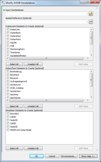
The Modify AHGW Geodatabase tool is accessed by double-clicking on "![]() Modify AHGW Geodatabase" under the "
Modify AHGW Geodatabase" under the "![]() Groundwater Analyst" toolset under the "
Groundwater Analyst" toolset under the "![]() Arc Hydro Groundwater Tools" toolbox.
Arc Hydro Groundwater Tools" toolbox.
The following fields are available. Required fields are marked with a ![]() icon.
icon.
 Input Geodatabase – Click the
  button to bring up the Input Geodatabase dialog in order to select the AHGW geodatabase to modify.
- Spatial Reference – Click the
 button to bring up the Spatial Reference Properties dialog in order to select the spatial reference of the feature dataset where the Arc Hydro Groundwater feature classes will be created.
 - Framework Datasets to Create – Select which Feature Classes and Tables from the Framework and Temporal sections of the AHGW Data Model to create. Options include:
- "WaterLine"
- "WaterBody"
- "Watershed"
- "WaterPoint"
- "Aquifer"
- "Well"
- "MonitoringPoint"
- "TimeSeries"
- "VariableDefinition"
- "SeriesCatalog"
- "DatasetCatalog"
- "RasterSeries"
- "FeatureSeries"
- Subsurface Datasets to Create – Select which Feature Classes and Tables from the Borehole, Hydrostratigraphy, and Geology sections of the AHGW Data Model to create. Options include:
- "BoreholeLog"
- "BorePoint"
- "BoreLine"
- "HydrogeologicUnit"
- "SectionLine"
- "XS2D_Catalog"
- "GeoSection"
- "GeoArea"
- "GeoVolume"
- "GeoRasters"
- "GeologyPoint"
- "GeologyLine"
- "GeologyArea"
- Simulation Datasets to Create – Select which Feature Classes and Tables from the Simulation section of the AHGW Data Model to create, along with the MODFLOW Data Model. Options include:
- "Boundary"
- "Cell2D"
- "Node2D"
- "Cell3D"
- "Bode3D"
- "MODFLOW Data Model"

