AHGW:Polygons to MODFLOW: Difference between revisions
(Created page with "350px|thumb|right|''Polygons to MODFLOW'' dialog The ''Polygons to MODFLOW'' tool is accessed by double-clicking...") |
m (Move page script moved page AHGW:Polygons to MODFLOW to Test:Polygons to MODFLOW without leaving a redirect) |
(No difference)
| |
Latest revision as of 23:40, 9 September 2019
The Polygons to MODFLOW tool is accessed by double-clicking on "![]() Polygons to MODFLOW" under the "
Polygons to MODFLOW" under the "![]() Tables" toolset under the "
Tables" toolset under the "![]() MODFLOW Analyst" toolset under the "
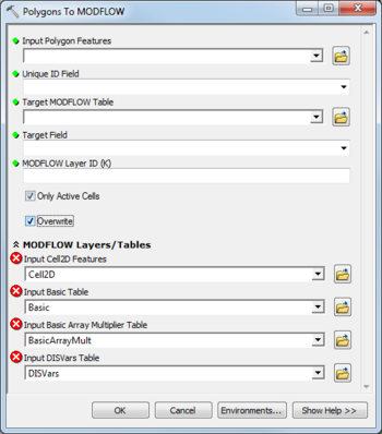
MODFLOW Analyst" toolset under the "![]() Arc Hydro Groundwater Tools" toolbox. This tool creates instances in a MODFLOW table from polygon features. The tool intersects input polygons with Cell2D features and creates MODFLOW instances (rows) in a MODFLOW table. Each row contains a grid index value (IJ or IJK), a SourceID value, and an intersection area (written to the target field). The SourceID of the MODFLOW instance is equal to a Unique ID (e.g., HydroID) of the polygon features. The intersection area is the area of the input polygon intersecting a Cell2D feature.
Arc Hydro Groundwater Tools" toolbox. This tool creates instances in a MODFLOW table from polygon features. The tool intersects input polygons with Cell2D features and creates MODFLOW instances (rows) in a MODFLOW table. Each row contains a grid index value (IJ or IJK), a SourceID value, and an intersection area (written to the target field). The SourceID of the MODFLOW instance is equal to a Unique ID (e.g., HydroID) of the polygon features. The intersection area is the area of the input polygon intersecting a Cell2D feature.
The following fields are available. Required fields are marked with a ![]() icon. Fields marked with a
icon. Fields marked with a ![]() icon may either not be supported or the table doesn't exist.
icon may either not be supported or the table doesn't exist.
 Input Polygon Features – Click the
  button to bring up the Input Polygon Features dialog in order to specify the input polygon features. MODFLOW instances (rows) are created by intersecting the polygons with Cell2D features.
 Unique ID Field – Select from a drop-down the unique ID of the input points (e.g., HydroID).
 Target MODFLOW Table – Click the
  button to bring up the Target MODFLOW Table dialog in order to specify the target MODFLOW table where instances will be created.
 Target Field – Select from a drop-down the field in the target table to which the area ratio (intersection area of input polygon and Cell2D feature) is written.
 MODFLOW Layer ID (K) – Enter the MODFLOW grid layer (K).
- Only Active Cells – Turn on to create instances for lines that intersect active cells only. Turn off to create instances for all lines intersecting Cell2D features.
- Overwrite – Turn on to clear the target table before creating new instances. Turn off to append new instances to the existing instances in the target table.
- MODFLOW Layers / Tables
- Input Cell2D Features – Click the
 button to bring up the Input Cell2D Features dialog in order to specify the layer in which to build the MODFLOW Cell2D features (part of the MODFLOW Data Model).
 - Input Basic Table – Click the
 button to bring up the Input Basic Table dialog in order to specify the Basic table (part of the MODFLOW Data Model).
 - Input Basic Array Multiplier Table – Click the
 button to bring up the Input Basic Array Multiplier Table dialog in order to specify the BasicArrayMult table (part of the MODFLOW Data Model).
 - Input DISVars Features – Click the
 button to bring up the Input DISVars Features dialog in order to specify the DISVars table (part of the MODFLOW Data Model).

