AHGW:Show/Hide Depth Range: Difference between revisions
From XMS Wiki
Jump to navigationJump to search
No edit summary |
No edit summary |
||
| (One intermediate revision by the same user not shown) | |||
| Line 1: | Line 1: | ||
{{SWFWMD}} | |||
[[File:AHGW Show-Hide Depth Range dialog.png|350px|thumb|right|''Show/Hide Depth Range'' dialog]] | [[File:AHGW Show-Hide Depth Range dialog.png|350px|thumb|right|''Show/Hide Depth Range'' dialog]] | ||
The ''Show/Hide Depth Range'' dialog is accessed by selecting ''Subsurface'' | '''Show or Hide Geophysical Data for Wells''' on the [[AHGW:Arc Hydro Groundwater Toolbar|Arc Hydro Groundwater Toolbar]]. This tool allows specific depth ranges in a geophysical point or line layer to be hidden from view in a geophysical plot or chart. | The ''Show/Hide Depth Range'' dialog<ref name="swfwmd" group="note">This tool was designed specifically for the Southwest Florida Water Management District, and has settings and features specific to them. We cannot guarantee this tool will be useful to anyone outside the SWFWMD.</ref> is accessed by selecting ''Subsurface'' | '''Show or Hide Geophysical Data for Wells''' on the [[AHGW:Arc Hydro Groundwater Toolbar|Arc Hydro Groundwater Toolbar]]. This tool allows specific depth ranges in a geophysical point or line layer to be hidden from view in a geophysical plot or chart. | ||
The following sections, options, and fields are available: | The following sections, options, and fields are available: | ||
| Line 12: | Line 13: | ||
*'''Reset All Layers''' – Resets (removes) all of the range depths in the spreadsheet and exits the ''Show/Hide Depth Range'' dialog. | *'''Reset All Layers''' – Resets (removes) all of the range depths in the spreadsheet and exits the ''Show/Hide Depth Range'' dialog. | ||
*'''Apply''' – Applies the range depth(s) in the spreadsheet and exits the ''Show/Hide Depth Range'' dialog. | *'''Apply''' – Applies the range depth(s) in the spreadsheet and exits the ''Show/Hide Depth Range'' dialog. | ||
==Notes== | |||
{{reflist|group="note"}} | |||
{{Navbox AHGW}} | {{Navbox AHGW}} | ||
[[Category:AHGW General Information]] | [[Category:AHGW General Information]] | ||
Latest revision as of 20:05, 30 October 2019
| This tool was designed specifically for the Southwest Florida Water Management District, and has settings and features specific to them. We cannot guarantee this tool will be useful to anyone outside the SWFWMD. |
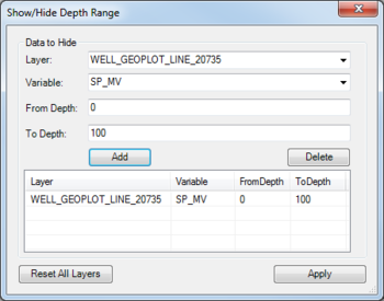
The Show/Hide Depth Range dialog[note 1] is accessed by selecting Subsurface | Show or Hide Geophysical Data for Wells on the Arc Hydro Groundwater Toolbar. This tool allows specific depth ranges in a geophysical point or line layer to be hidden from view in a geophysical plot or chart.
The following sections, options, and fields are available:
- Data to Hide section
- Layer – A drop-down allowing selection of a specific geophysical layer.
- Variable – A drop-down allowing selection of a specific geophysical variable.
- From Depth – A numeric starting value for the depth range to hide.
- To Depth – A numeric ending value for the depth range to hide.
- Add – Adds a row to the list of ranges.
- Delete – Removes the selected range from the spreadsheet.
- Reset All Layers – Resets (removes) all of the range depths in the spreadsheet and exits the Show/Hide Depth Range dialog.
- Apply – Applies the range depth(s) in the spreadsheet and exits the Show/Hide Depth Range dialog.
Notes
- ^ This tool was designed specifically for the Southwest Florida Water Management District, and has settings and features specific to them. We cannot guarantee this tool will be useful to anyone outside the SWFWMD.

