Search results
From XMS Wiki
Jump to navigationJump to search
File:WMS MapProjectExplorer3.png [[Category:Project Explorer images]] ...t/view the Properties of the coverage, or perform a Coordinate Conversion. Properties include the name and coverage type.(365 × 461 (21 KB)) - 17:23, 9 March 2018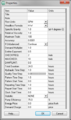
File:EPANET ProjectParameters.png EPANET project ''Properties'' dialog in WMS.(345 × 582 (18 KB)) - 15:35, 17 January 2017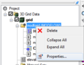
File:ModflowProperties.png [[Category:Project Explorer Images]] How to reach the MODFLOW Solution Properties dialog(265 × 206 (11 KB)) - 17:20, 9 June 2017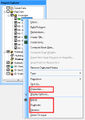
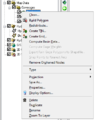
File:CoverageMenu2.jpg [[Category:Project Explorer images]] ...bring up a menu with the following options: Delete, Duplicate, Rename, and Properties(421 × 592 (72 KB)) - 15:33, 20 February 2017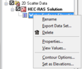
File:WMS ScatterProjectExplorer4.png [[Category:Project Explorer images]] ...icking on one of the datasets allows users to Delete, Export, Rename, view Properties, or View Values of the dataset.(248 × 208 (6 KB)) - 14:33, 12 March 2018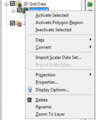
File:WMS GridProjectExplorer3.png [[Category:Project Explorer images]] Right-clicking on the dataset for a grid allows users to Export, Rename, view Properties, View Values, set Contour Options, and Set as Elevations.(264 × 330 (11 KB)) - 17:14, 9 March 2018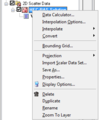
File:WMS ScatterProjectExplorer3.png [[Category:Project Explorer images]] ...ataset allows users to allows to create a New folder, Delete, Rename, view Properties, and Convert Coordinate Systems of the scattered dataset.(280 × 340 (10 KB)) - 14:33, 12 March 2018
File:WMS HY12 Properties.png HY-12 Project Properties dialog.(840 × 638 (47 KB)) - 17:30, 4 December 2015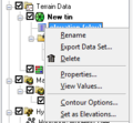
File:TerrainProjectExplorer4.png [[Category:Project Explorer images]] ...king on a dataset of a TIN allows the user to Delete, Export, Rename, view Properties, View values, set the dataset as elevations, or set the dataset contour opt(228 × 210 (9 KB)) - 16:30, 8 March 2018


