Search results
From XMS Wiki
Jump to navigationJump to search
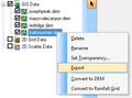
File:RasterDataExport.png ...rmation about land use or soil type can be converted to a land use or soil type grid by right-clicking on the layer.(336 × 250 (9 KB)) - 15:10, 20 February 2017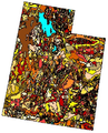
File:GSDA NRCS STATSGO Soil Type.png NRCS STATSGO soil type for the state of Utah.(343 × 426 (248 KB)) - 14:34, 1 November 2017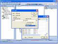
File:WMS JoinTableShapefile.jpg ...ure is commonly used to join a separate table of soil attributes to a soil type shapefile in order to compute composite Curve Numbers.(738 × 558 (88 KB)) - 16:04, 9 January 2017
File:GSDA EPA Soil Type.png EPA soil type for an EPA watershed near Provo, Utah.(400 × 152 (70 KB)) - 14:32, 1 November 2017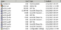
File:GSDA SHPdirectory.png ...ind several shapefiles; the shapefile containing an "_a" contains the soil type polygon shapes.(459 × 226 (6 KB)) - 15:10, 2 November 2017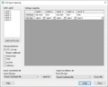
File:SoilAtts.png Soil Type Mapping dialog(652 × 528 (13 KB)) - 18:45, 5 January 2024


