|
|
| (One intermediate revision by the same user not shown) |
| Line 34: |
Line 34: |
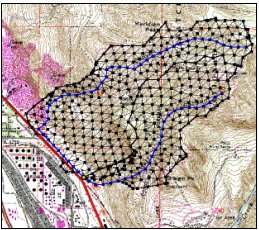
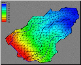
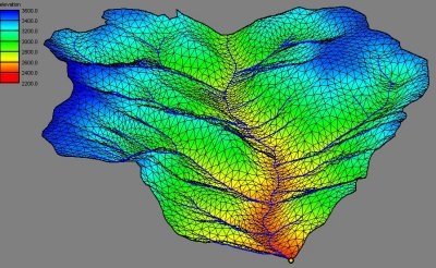
| * Survey data and known elevations can easily be incorporated into a TIN. | | * Survey data and known elevations can easily be incorporated into a TIN. |
| * Some functions cannot be performed with DEM data, but are easily done with a TIN. Examples of this include creating storage-capacity curves for reservoirs, floodplain delineation, and computing time-area curves for hydrographs. | | * Some functions cannot be performed with DEM data, but are easily done with a TIN. Examples of this include creating storage-capacity curves for reservoirs, floodplain delineation, and computing time-area curves for hydrographs. |
|
| |
| ==Composite Runoff Coefficients==
| |
| WMS can compute Composite Runoff Coefficients for the basin(s) in your watershed. To accomplish this, you will need to create a table that links a soil type's ID number (from a soil type grid or polygon coverage) to a runoff coefficient. Note that WMS automatically creates a soil ID number for each different soil encountered upon importing a soil type grid or soil type shapefile. Refer to the following steps for help to create a Runoff Coefficient table. Below these steps is a table containing suggested runoff coefficients based on a soil's management type and hydrologic soil group.
| |
|
| |
| Steps for selecting a runoff coefficient for a soil ID number:
| |
|
| |
| For each soil type ID in WMS
| |
|
| |
| <ol>
| |
| <li>Determine the land use / vegetation category for the soil ID in question, such as cultivated, pasture, urban, etc.</li>
| |
| <li>Determine the hydrologic soil group of this ID, <br>To determine the soil group (A, B, C, or D) of a soil ID after importing the soil type file into WMS:<br>
| |
| <ol>
| |
| <li>Select Display | Display Options...
| |
| <li>Choose the MAP tab
| |
| <li>Switch the Active Coverage drop-down list to Soil Type
| |
| <li>Toggle On the box for displaying the Soil Group Legend
| |
| <li>Select OK
| |
| </ol><br>You will now see a small legend in the upper-left corner of the WMS graphics window that lists the soil IDs with their respective soil groups.<br>
| |
| [[Image:GSDA Soil Legend.png]]</li><br>
| |
| <li>Pick the Runoff Coefficient for the given land use / vegetation and hydrologic soil group using table like the one below these steps.</li>
| |
| <li>Create a 3-column text file containing the soil ID, a description, and its coefficient, following this format: <br>soil ID, description (in quotes), runoff coefficient</li>
| |
| <pre>
| |
| Example
| |
|
| |
| 0, "Type1", 0.1
| |
| 1, "Type2", 0.2
| |
| 2, "Type3", 0.3
| |
| 3, "Type4", 0.4
| |
| 4, "Type5", 0.5
| |
| 5, "Type6", 0.6
| |
| 6, "Type7", 0.7
| |
| 7, "Type8", 0.8
| |
| 8, "Type9", 0.9
| |
| </pre>
| |
| <li>Save the file, preferably with a *.tbl extension.</li>
| |
| </ol>
| |
|
| |
| This file can now be read into WMS in order to calculate a composite Runoff Coefficient for you watershed basin(s).<br>
| |
| For help in performing this calculation in WMS, refer to the WMS Help menu.<br>
| |
|
| |
| ==Table of Runoff Coefficients for the Rational Equation: Q=kCiA==
| |
|
| |
|
| |
| '''Hydrologic Soil Group'''
| |
| '''Land Use, Crop, and Management''' A B C D
| |
| CULTIVATED, with crop rotations
| |
| Row Crops, poor management 0.55 0.65 0.70 0.75
| |
| Row Crops, conservation mgmt 0.50 0.55 0.65 0.70
| |
| Small Grains, poor management 0.35 .40 0.45 0.50
| |
| Small Grains, conservation mgmt 0.20 .022 0.25 0.30
| |
| Meadow 0.30 0.35 0.40 0.45
| |
| PASTURE, permanent w/moderate grazing 0.10 0.20 0.25 0.30
| |
| WOODS, permanent, mature, no grazing 0.06 0.13 0.16 0.20
| |
| Urban Residential
| |
| 30 percent of area impervious 0.30 0.40 0.45 0.50
| |
| 70 percent of area impervious 0.50 0.60 0.70 0.80
| |
|
| |
| '''Hydrologic Soil Group Descriptions'''
| |
| A -- Well-drained sand and gravel; high permeability.
| |
| B -- Moderate to well-drained; moderately fine to moderately coarse texture; moderate permeability.
| |
| C -- Poor to moderately well-drained; moderately fine to fine texture; slow permeability.
| |
| D -- Poorly drained, clay soils with high swelling potential, permanent high water table, claypan, or shallow soils over nearly impervious layer(s).
| |
|
| |
|
| |
| * This table was obtained from http://pasture.ecn.purdue.edu/~engelb/abe526/Runoff/C_table.html
| |
|
| |
| ==Listing of Public Sites in Various States==
| |
| * [http://www.gsa.state.al.us/gsa/gis/DATA.html Alabama] - State of Alabama Geological Survey
| |
| * ''Alaska''
| |
| * [http://aria.arizona.edu/images/ Arizona - Arizona] Regional Images Archive, University of Arizona
| |
| * [http://www.cast.uark.edu/cast/geostor/index.html Arkansas] - Geostor: The On-line Arkansas Spatial Data Infrastructure
| |
| * [http://www.gis.ca.gov/ California - California] Spatial Information Library
| |
| * ''Colorado''
| |
| * [http://magic.lib.uconn.edu/index.html Connecticut]
| |
| * [http://www.rdms.udel.edu/rdms/gis/drgdlg/ Delaware] - Research Data Management Services-University of Delaware
| |
| * [http://www.labins.org/ Florida] - Florida Dept. of Environmental Protection - Land Boundary Information System (LABINS)
| |
| * [http://csat.gatech.edu/drg/drg.html Georgia] - USGS-WRD/Georgia Tech-Center for Spatial Analysis Technologies
| |
| * ''Hawaii''
| |
| * [http://geolibrary.uidaho.edu/ Idaho] - Idaho Geospatial Data Center
| |
| * [http://www.isgs.uiuc.edu/nsdihome/ISGSindex.html Illinois] - Illinois Natural Resources Geospatial Data Clearinghouse
| |
| * ''Indiana''
| |
| * [http://www.igsb.uiowa.edu/nrgis/gishome.htm Iowa] - Iowa Department of Natural Resources
| |
| * [http://mapster.kgs.ukans.edu/dasc/catalog/coredata.html Kansas] - State of Kansas GIS Initiative - Data Access and Support Center
| |
| * [http://kymartian.state.ky.us/drgmaps/ Kentucky]
| |
| * [http://atlas.lsu.edu/ Louisiana] - Louisiana Statewide GIS
| |
| * ''Maine''
| |
| * ''Maryland''
| |
| * [http://www.state.ma.us/mgis/download.htm Massachusetts] - Mass GIS
| |
| * [http://www.state.mi.us/webapp/cgi/mgdl/ Michigan] - MI Geographic Data Library
| |
| * [http://www.umesc.usgs.gov/data_library/maps_quads_figs/drg.html Minnesota] - USGS Upper Midwest Environmental Sciences Center
| |
| * [http://www.maris.state.ms.us/drg/drg.html Mississippi] - MARIS (Mississippi Automated Resource Information System)
| |
| * [http://msdis.missouri.edu/data.html Missouri] - Missouri Spatial Data Information Service
| |
| * [http://nris.state.mt.us/nsdi/drg.html Montana] - Montana State Library - Natural Resource Information System
| |
| * [http://csd.unl.edu/general/drgdownloads.asp Nebraska] - Conservation and Survey Division (CSD) of the University of Nebraska-Lincoln
| |
| * [http://www.nbmg.unr.edu/drg.html Nevada] - Nevada Bureau of Mines and Geology FTP Site
| |
| * ''New Hampshire''
| |
| * ''New Jersey''
| |
| * [http://sar.lanl.gov/topo_maps/ New Mexico] - Los Alamos National Laboratory
| |
| * [http://www.nysgis.state.ny.us/index.html New York] - New York State GIS Clearinghouse
| |
| * [http://www.state.nd.us/ndgs/GISInfo/datawearhouse.html North Dakota] - North Dakota Geological Survey
| |
| * [http://www.state.oh.us/das/dcs/gis/drg/index.htm Ohio] - Ohio Department of Administrative Services
| |
| * [http://www.geo.ou.edu/ Oklahoma] - GEO Information Systems - University of Oklahoma
| |
| * [http://www.reo.gov/reo/data/data.htm Oregon] - Regional Ecosystem Office
| |
| * [http://www.maproom.psu.edu/drg1/ Pennsylvania] - Pennsylvania State University
| |
| * ''Rhode Island''
| |
| * ''South Carolina''
| |
| * [http://www.sdgs.usd.edu/register South Dakota] - Department of Environment and Natural Resources
| |
| * ''Tennessee''
| |
| * ''Texas''
| |
| * [http://agrc.its.state.ut.us/ Utah] - Utah's Automated Geographic Reference Center
| |
| * ''Vermont''
| |
| * [http://www.lib.vt.edu/subjects/maps/drgtopo.html Virginia] - Virginia Tech University Libraries
| |
| * [http://www.reo.gov/reo/data/data.htm Washington] - Regional Ecosystem Office
| |
| * [http://129.71.240.42/data/ West Virginia] - West Virginia Division of Environmental Protection
| |
| * [http://www.umesc.usgs.gov/data_library/maps_quads_figs/drg.html Wisconsin] - USGS Upper Midwest Environmental Sciences Center
| |
| * [http://wgiac2.state.wy.us/html/AboutDRG.asp Wyoming] - Wyoming Spatial Data Clearinghouse
| |