WMS:HEC-HMS Convert Grids
From XMS Wiki
Jump to navigationJump to search
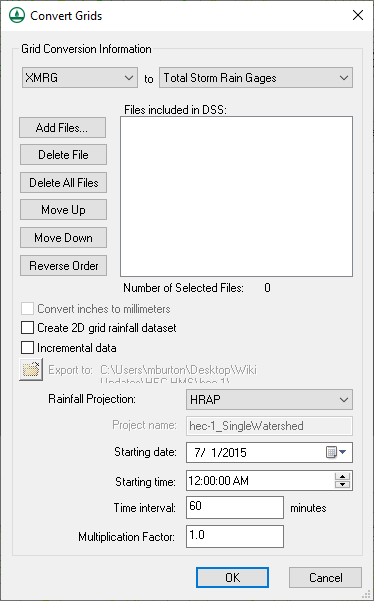
The Convert Grids dialog is used to manage the process of converting NEXRAD RADAR rainfall grids in XMRG or ASCII grid format to a format that is usable with WMS or HMS. This dialog is available if the Gridded Precipitation option or the User Gage Weighting option is selected in the HMS Meteorological Model dialog.
The following commands are available in this dialog:
- ASCII grid to DSS – Converts rainfall grids in ArcInfo ASCII grid format to a gridded DSS file. The Export to directory defines the export directory and the Project name defines the DSS filename. Since the DSS file also contains date and time information, the specified Starting date and Starting time will determine the starting time of the first grid in the file list. Each additional grid will be saved to the DSS file based on the time interval specified in the HMS Job Control dialog and listed at the bottom of this dialog.
- XMRG to DSS – First converts XMRG grids to Arc/Info ASCII grid format then converts the grids to a gridded DSS file. Everything else is done in the same manner as the ASCII grid to DSS command.
- XMRG to Incremental Distribution Rain Gages – Converts the points in an XMRG file to incremental distribution rain gages in a rain gage coverage. These gages can then be tied to a basin in a hydrologic model. When the points in the rain gage coverage are created, their coordinates are converted to the current coordinate system, if one is defined. This command will not function unless the current coordinate system is defined.
- XMRG to Total Storm Rain Gages – Converts the points in an XMRG file to total storm rain gages in a rain gage coverage. The coordinate system of the points is converted to the current coordinate system.
Related Topics:
WMS – Watershed Modeling System | ||
|---|---|---|
| Modules: | Terrain Data • Drainage • Map • Hydrologic Modeling • River • GIS • 2D Grid • 2D Scatter |  |
| Models: | CE-QUAL-W2 • GSSHA • HEC-1 • HEC-HMS • HEC-RAS • HSPF • MODRAT • NSS • OC Hydrograph • OC Rational • Rational • River Tools • Storm Drain • SMPDBK • SWMM • TR-20 • TR-55 | |
| Toolbars: | Modules • Macros • Units • Digitize • Static Tools • Dynamic Tools • Drawing • Get Data Tools | |
| Aquaveo | ||
