File:Tccalcparms.jpg
From XMS Wiki
Jump to navigationJump to search
No higher resolution available.
Tccalcparms.jpg (350 × 321 pixels, file size: 57 KB, MIME type: image/jpeg)
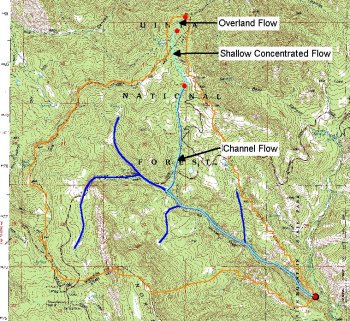
A GIS vector coverage for time computations can be defined and then separate arcs (lines) used to define different equations. The sum of the travel times for the arcs within the basin is then used for time of concentration or lag time.
File history
Click on a date/time to view the file as it appeared at that time.
| Date/Time | Thumbnail | Dimensions | User | Comment | |
|---|---|---|---|---|---|
| current | ★ Approved revision 17:45, 14 August 2007 | | 350 × 321 (57 KB) | Trabadi (talk | contribs) |
You cannot overwrite this file.
File usage
The following page uses this file: