SMS:Sediment Volume Management
| This feature is currently in Beta release for SMS Some features and capabilities are still in development for SMS. |
The Sediment Volume Management coverage allows for calculating cut and fill for sediment volume. The coverage allows for assigning sediment attributes to polygons and also provides a tool to perform sediment volume calculations. The coverage needs to be set to the Sediment Volume Management type.
Sediment Volume Management Polygon Attributes
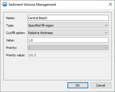
The Sediment Volume Management dialog for polygon attributes can be reached by right-clicking on a selected polygon and selecting the Sediment Properties... command. The dialog contains the following properties:
- Name – This allows for a name to be entered.
- Type – This allows the type to be specified, including the following options:
- "None"
- "Specified cut region"
- "Specified fill region"
- "Available cut region"
- "Available fill region"
- Cut/fill option – When enabled, this allows the cut/fill option to be specified, including the following options:
- "Constant elevation"
- "Relative thickness"
- "Total volume by elevation"
- "Total volume by thickness"
- Value – This allows a value to be specified.
- Priority – This represents the priority.
- Priority value – This represents the priority value.
Sediment Volume Management Tool
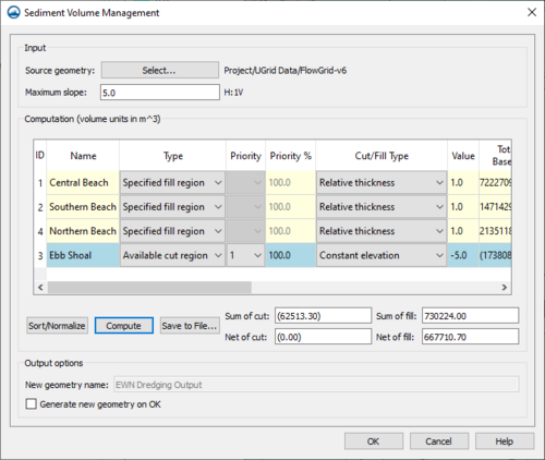
The Sediment Volume Management tool dialog is reached by right-clicking on the sediment volume management coverage and selecting the Sediment Volume Management... command. There must already be at least one Sediment Volume Management Polygon Attribute created for the dialog to appear. The dialog has the following options, split into the sections they are found in:
Input
- Source geometry Select... – This will bring up the Select EWN Geometry dialog, where the source geometry can be selected for use.
- Maximum slope – This allows a maximum slope to be specified.
Computations (volume units in ft^3)
- Computation table – A region that contains a list of all the attributes and their data, some of which can be altered within the table. It has columns for the following data, which are gathered from what was entered for Sediment Volume Management Polygon Attributes:
- ID – This is the ID that was assigned for the region.
- Name – This is the name that was entered for the region.
- Type – This is the type that was specified for the region.
- Priority – This is the priority that was assigned for the region.
- Priority% – This is the the priority value that was assigned for the region.
- Cut/Fill Type – This is the Cut/Fill type that was assigned for the region.
- Value – This is the value that was assigned for the region.
- Total Volume Based on Slope – This is the amount of material that could be dredged/placed if the specified depth/elevation values were ignored.
- Required Volume – This is the volume for specified cuts/fills.
- Available Volume – This is the volume for available cuts/fills.
- Cut Volume – This is the actual amount cut from this polygon.
- Fill Volume – This is the actual amount placed into this polygon.
- Sort/Normalize – This deals with the priority column, it will normalize the priority values for them to be accurate percentages and sort them.
- Compute – This runs the Sediment Volume Management tool and updates the values in the Computation table.
- Save to File – This will bring up the Save dialog, where a file can be saved of the output.
- Sum of cut – This allows the sum of cut to be entered.
- Net of cut – This allows the net of cut to be entered.
- Sum of fill – This allows the sum of fill to be entered.
- Net of fill – This allows the net of fill to be entered.
Output options
- New geometry name – This allows a name for a new geometry to be entered.
- Generate new geometry on OK – Checking this will mean that a new geometry is generated when OK is selected on the dialog.
Related Topics
SMS – Surface-water Modeling System | ||
|---|---|---|
| Modules: | 1D Grid • Cartesian Grid • Curvilinear Grid • GIS • Map • Mesh • Particle • Quadtree • Raster • Scatter • UGrid |  |
| General Models: | 3D Structure • FVCOM • Generic • PTM | |
| Coastal Models: | ADCIRC • BOUSS-2D • CGWAVE • CMS-Flow • CMS-Wave • GenCade • STWAVE • WAM | |
| Riverine/Estuarine Models: | AdH • HEC-RAS • HYDRO AS-2D • RMA2 • RMA4 • SRH-2D • TUFLOW • TUFLOW FV | |
| Aquaveo • SMS Tutorials • SMS Workflows | ||

