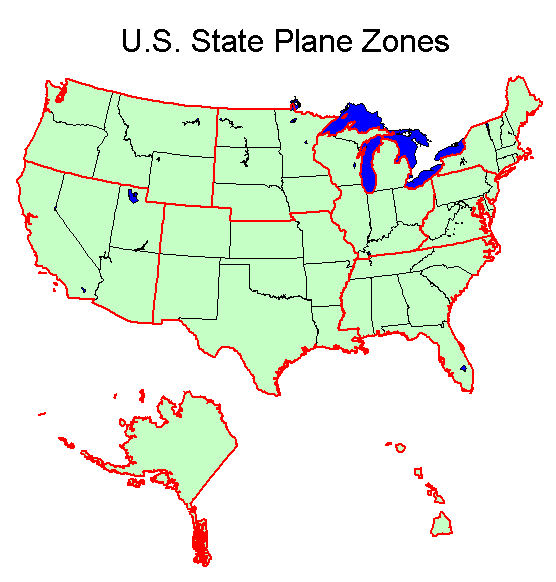
A State Plane system is a coordinate system used in the US. Each US state is divided into one or more zones, known as State Plane zones. Supported State Plane systems include:
- NAD (North American Datum) 1927
- NAD 1983
Additionally, an HPGN (High Precision Geodetic Network, now known as HARN – High Accuracy Precision Network) zone can be specified for each state plane zone.
The boundary of most of the state plane zones remained the same from 1927 to 1983. The US State Plane Zones are shown in the map below. The boundaries are shown for each state plane zone in the following sections. The boundaries that changed between 1927 and 1983 are highlighted for each state plane zone that changed.
State Zone Maps
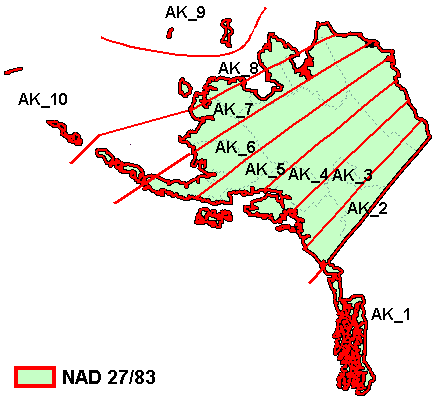
Alaska
The figure below shows the state plane zones for the Alaska area.
| NAD 27 / 83
|
| Zone Name |
Map Code |
Zone ID
|
| Alaska 1
|
| Alaska 2
|
| Alaska 3
|
| Alaska 4
|
| Alaska 5
|
| Alaska 6
|
| Alaska 7
|
| Alaska 8
|
| Alaska 9
|
| Alaska 10
|
|
| AK_1
|
| AK_2
|
| AK_3
|
| AK_4
|
| AK_5
|
| AK_6
|
| AK_7
|
| AK_8
|
| AK_9
|
| AK_10
|
|
| 5001
|
| 5002
|
| 5003
|
| 5004
|
| 5005
|
| 5006
|
| 5007
|
| 5008
|
| 5009
|
| 5010
|
|
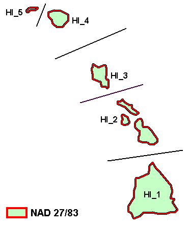
Hawaii
The figure below shows the state plane zones for the Hawaii area.
| NAD 27 / 83
|
| Zone Name |
Map Code |
Zone ID
|
| Hawaii 1
|
HI_1
|
5101
|
| Hawaii 2
|
HI_2
|
5102
|
| Hawaii 3
|
HI_3
|
5103
|
| Hawaii 4
|
HI_4
|
5104
|
| Hawaii 5
|
HI_5
|
5105
|
Mideast
The figure below shows the state plane zones for the Mideast area.
| NAD 27 / 83
|
| Zone Name |
Map Code |
Zone ID
|
| Illinois East
|
| Illinois West
|
| Indiana East
|
| Indiana West
|
| Kentucky North
|
| Kentucky South
|
| Michigan East (NAD 27)
|
| Michigan Central (NAD 27)
|
| Michigan West (NAD 27)
|
| Ohio North
|
| Ohio South
|
| Wisconsin North
|
| Wisconsin Central
|
| Wisconsin South
|
|
| IL_E
|
| IL_W
|
| IN_E
|
| IN_W
|
| KY_N
|
| KY_S
|
| MI_E
|
| MI_C
|
| MI_W
|
| OH_N
|
| OH_S
|
| WI_N
|
| WI_C
|
| WI_S
|
|
| 1201
|
| 1202
|
| 1301
|
| 1302
|
| 1601
|
| 1602
|
| 2101
|
| 2102
|
| 2103
|
| 3401
|
| 3402
|
| 4801
|
| 4802
|
| 4803
|
|
| NAD 83 Zone Changes
|
| Michigan North
|
| Michigan Central
|
| Michigan South
|
|
|
|
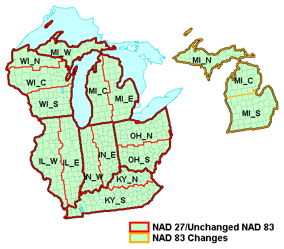
Midwest
The figure below shows the state plane zones for the Midwest area.

| NAD 27 / 83
|
| Zone Name |
Map Code |
Zone ID
|
| Iowa North
|
| Iowa South
|
| Minnesota North
|
| Minnesota Central
|
| Minnesota South
|
| Nebraska North
|
| Nebraska South
|
| North Dakota North
|
| North Dakota South
|
| South Dakota North
|
| South Dakota South
|
|
| IA_N
|
| IA_S
|
| MN_N
|
| MN_C
|
| MN_S
|
| NE_N
|
| NE_S
|
| ND_N
|
| ND_S
|
| SD_N
|
| SD_S
|
|
| 1401
|
| 1402
|
| 2201
|
| 2202
|
| 2203
|
| 2601
|
| 2602
|
| 3301
|
| 3302
|
| 4001
|
| 4002
|
|
| NAD 83 Zone Changes
|
|
|
|
|
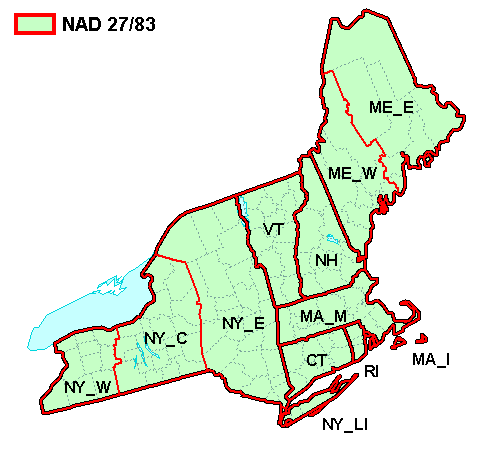
New England
The figure below shows the state plane zones for the New England area.
| NAD 27 / 83
|
| Zone Name |
Map Code |
Zone ID
|
| Connecticut
|
| Maine East
|
| Maine West
|
| Massachusetts Mainlaine
|
| Massachusetts Island
|
| New Hampshire
|
| New York East
|
| New York Central
|
| New York West
|
| New York Long Island
|
| Rhode Island
|
| Vermont
|
|
| CT
|
| ME_E
|
| ME_W
|
| MA_M
|
| MA_I
|
| NH
|
| NY_E
|
| NY_C
|
| NY_W
|
| NY_LI
|
| RI
|
| VT
|
|
| 0600
|
| 1801
|
| 1802
|
| 2001
|
| 2002
|
| 2800
|
| 3101
|
| 3102
|
| 3103
|
| 3104
|
| 3800
|
| 4400
|
|
Northwest
The figure below shows the state plane zones for the Northwest area.
| NAD 27 / 83
|
| Zone Name |
Map Code |
Zone ID
|
| Idaho East
|
| Idaho Central
|
| Idaho West
|
| Montana North
|
| Montana Central
|
| Montana South
|
| Oregon North
|
| Oregon South
|
| Washington North
|
| Washington South
|
| Wyoming I
|
| Wyoming II
|
| Wyoming III
|
| Wyoming IV
|
|
| ID_E
|
| ID_C
|
| ID_W
|
| MT_N
|
| MT_C
|
| MT_S
|
| OR_N
|
| OR_S
|
| WA_N
|
| WA_S
|
| WY_E
|
| WY_EC
|
| WY_WC
|
| WY_W
|
|
| 1101
|
| 1102
|
| 1103
|
| 2501
|
| 2502
|
| 2503
|
| 3601
|
| 3602
|
| 4601
|
| 4602
|
| 4901
|
| 4902
|
| 4903
|
| 4904
|
|
| NAD 83 Zone Changes
|
|
|
|
|
| NAD 83 Name Changes
|
| Wyoming East
|
| Wyoming East Central
|
| Wyoming West Central
|
| Wyoming West
|
|
|
|
| NAD 83 Boundary Changes
|
| Washington North
|
| Washington South
|
|
|
|
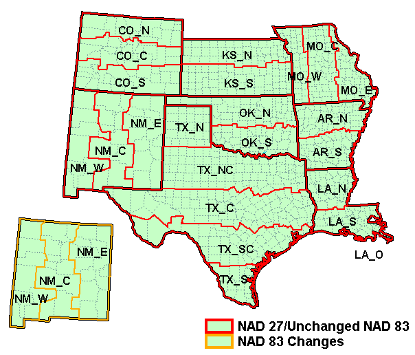
South Central
The figure below shows the state plane zones for the South Central area.
| NAD 27 / 83
|
| Zone Name |
Map Code |
Zone ID
|
| Arkansas North
|
| Arkansas South
|
| Colorado North
|
| Colorado Central
|
| Colorado South
|
| Kansas North
|
| Kansas South
|
| Louisiana North
|
| Louisiana South
|
| Louisiana Offshore
|
| Missouri East
|
| Missouri Central
|
| Missouri West
|
| New Mexico East
|
| New Mexico Central
|
| New Mexico West
|
| Oklahoma North
|
| Oklahoma South
|
| Texas North
|
| Texas North Central
|
| Texas Central
|
| Texas South Central
|
| Texas South
|
|
| AR_N
|
| AR_S
|
| CO_N
|
| CO_C
|
| CO_S
|
| KS_N
|
| KS_S
|
| LA_N
|
| LA_S
|
| LA_O
|
| MO_E
|
| MO_C
|
| MO_W
|
| NM_E
|
| NM_C
|
| NM_W
|
| OK_N
|
| OK_S
|
| TX_N
|
| TX_NC
|
| TX_C
|
| TX_SC
|
| TX_S
|
|
| 0301
|
| 0302
|
| 0501
|
| 0502
|
| 0503
|
| 1501
|
| 1502
|
| 1701
|
| 1702
|
| 1703
|
| 2401
|
| 2402
|
| 2403
|
| 3001
|
| 3002
|
| 3003
|
| 3501
|
| 3502
|
| 4201
|
| 4202
|
| 4203
|
| 4204
|
| 4205
|
|
| NAD 83 Boundary Changes
|
| New Mexico East
|
| New Mexico Central
|
| New Mexico West
|
|
|
|
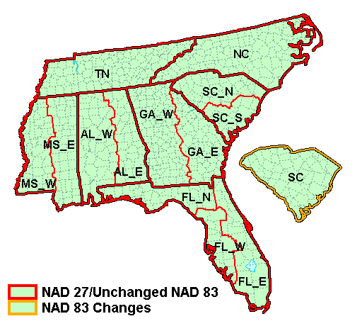
Southeast
The figure below shows the state plane zones for the Southeast area.
| NAD 27 / 83
|
| Zone Name |
Map Code |
Zone ID
|
| Alabama East
|
| Alabama West
|
| Florida East
|
| Florida West
|
| Florida North
|
| Georgia East
|
| Georgia West
|
| Mississippi East
|
| Mississippi West
|
| North Carolina
|
| South Carolina North
|
| South Carolina South
|
| Tennessee
|
|
| AL_E
|
| AL_W
|
| FL_E
|
| FL_W
|
| FL_N
|
| GA_E
|
| GA_W
|
| MS_E
|
| MS_W
|
| NC
|
| SC_N
|
| SC_S
|
| TN
|
|
| 0101
|
| 0102
|
| 0901
|
| 0902
|
| 0903
|
| 1001
|
| 1002
|
| 2301
|
| 2302
|
| 3200
|
| 3901
|
| 3902
|
| 4100
|
|
| NAD 83 Zone Changes
|
|
|
|
|
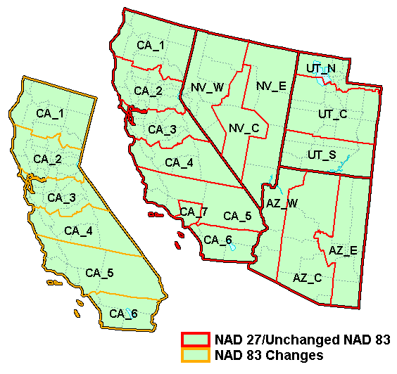
Southwest
The figure below shows the state plane zones for the Southwest area.
| NAD 27 / 83
|
| Zone Name |
Map Code |
Zone ID
|
| Arizona East
|
| Arizona Central
|
| Arizona West
|
| California 1
|
| California 2
|
| California 3
|
| California 4
|
| California 5
|
| California 6
|
| California 7
|
| Nevada East
|
| Nevada Central
|
| Nevada West
|
| Utah North
|
| Utah Central
|
| Utah South
|
|
| AZ_E
|
| AZ_C
|
| AZ_W
|
| CA_1
|
| CA_2
|
| CA_3
|
| CA_4
|
| CA_5
|
| CA_6
|
| CA_7
|
| NV_E
|
| NV_C
|
| NV_W
|
| UT_N
|
| UT_C
|
| UT_S
|
|
| 0201
|
| 0202
|
| 0203
|
| 0401
|
| 0402
|
| 0403
|
| 0404
|
| 0405
|
| 0406
|
| 0407
|
| 2701
|
| 2702
|
| 2703
|
| 4301
|
| 4302
|
| 4303
|
|
| NAD 83 Subtractions
|
|
|
|
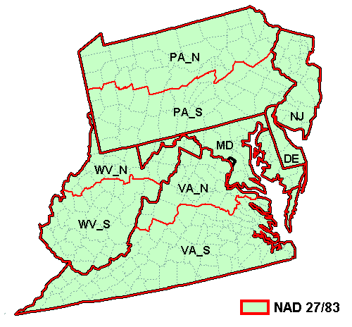
Virginia Area
The figure below shows the state plane zones for the Virginia area.
| NAD 27 / 83
|
| Zone Name |
Map Code |
Zone ID
|
| Delaware
|
| District of Columbia / Maryland
|
| New Jersey
|
| Pennsylvania North
|
| Pennsylvania South
|
| Virgina North
|
| Virgina South
|
| West Virginia North
|
| West Virginia South
|
|
| DE
|
| MD
|
| NJ
|
| PA_N
|
| PA_S
|
| VA_N
|
| VA_S
|
| WV_N
|
| WV_S
|
|
| 0700
|
| 1900
|
| 2900
|
| 3701
|
| 3702
|
| 4501
|
| 4502
|
| 4701
|
| 4702
|
|
Related Topics
Projections


