Search results
From XMS Wiki
Jump to navigationJump to search
Page title matches
- ...arcs. Most of these can be accessed by selecting and right-clicking on the arcs that are to be operated on. This command deletes the selected arcs. SMS will prompt to confirm that the deletion is desired if the ''Confirm29 KB (5,004 words) - 19:19, 23 February 2024
- 33 bytes (4 words) - 17:12, 16 October 2013
- #REDIRECT [[WMS:GSSHA Embankment Arcs]]39 bytes (5 words) - 18:46, 3 September 2013
- #REDIRECT [[SMS:Arcs]]22 bytes (3 words) - 15:09, 3 June 2013
- #REDIRECT [[SMS:Arcs]]22 bytes (3 words) - 15:10, 3 June 2013
- #redirect [[SMS:Feature Objects Types#Arcs]]44 bytes (6 words) - 17:21, 7 August 2015
- ===Polygons from Arcs=== The ''Polygons from Arcs'' tool converts all arcs in a coverage to polygons based on specified parameters.7 KB (1,085 words) - 19:58, 25 October 2023
- 33 bytes (4 words) - 17:12, 16 October 2013
- #REDIRECT [[SMS:Arcs]]22 bytes (3 words) - 15:55, 3 June 2013
- #REDIRECT [[SMS:Arcs]]22 bytes (3 words) - 16:04, 3 June 2013
- #REDIRECT [[WMS:GSSHA Feature Arcs]]36 bytes (5 words) - 20:24, 3 September 2013
- 38 bytes (5 words) - 15:42, 13 August 2013
- ===Arcs from UGrid Points=== ...ints on a UGrid that are close to each other and convert these clusters to arcs.1 KB (181 words) - 23:14, 14 May 2024
- ...are placed along the centerline of the actual embankment. These embankment arcs often represent roads that cross a drainage. The embankment arc can interse These feature arcs are then mapped to the nearest cell edge. The embankment acts as a wall all5 KB (725 words) - 19:38, 22 May 2019
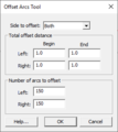
File:Offset Arcs Tool.png Offset Arcs Tool dialog(271 × 305 (7 KB)) - 14:43, 10 September 2019- 39 bytes (5 words) - 17:07, 21 November 2017
- ...ied, depending on the type of feature arc. There are five types of feature arcs in GSSHA for standard GSSHA coverages: ...''Properties'' dialog is where the attributes are associated with feature arcs.|}}15 KB (2,242 words) - 21:51, 7 July 2020
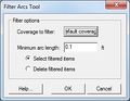
File:Filter Arcs Tool.jpg Filter Arcs Tool dialog(285 × 222 (15 KB)) - 17:29, 27 April 2021- 38 bytes (5 words) - 21:54, 21 May 2019
- 37 bytes (4 words) - 17:08, 29 October 2013


Page text matches
- ...ified in the coverage properties dialog apply to any geometry modification arcs and polygons within the coverage. If you want to use multiple settings with # All Zpts (default) - The z values from all of the arcs/polygons are used.1 KB (212 words) - 17:17, 5 May 2008
File:UtexasHeadDisplayOption.png Arcs designated as Head arcs have the space above them filled with the specified color.(722 × 336 (9 KB)) - 17:29, 11 August 2017- ...The arcs must be straight lines, because bouss only supports straight line arcs.375 bytes (56 words) - 16:11, 28 March 2013
File:Tccalcparms.jpg ...s) used to define different equations. The sum of the travel times for the arcs within the basin is then used for time of concentration or lag time.(350 × 321 (57 KB)) - 15:51, 23 September 2014- ===Arcs from UGrid Points=== ...ints on a UGrid that are close to each other and convert these clusters to arcs.1 KB (181 words) - 23:14, 14 May 2024
- ...a node is created at the intersection and the arcs are split into smaller arcs. ...' – This option is the same as the previous option but only selected arcs are checked for intersections.1 KB (231 words) - 20:40, 7 February 2024
- ...age. Nodes that are within the polygons or located a specified distance of arcs will be assigned the value 1.0 ("locked") and all other nodes will be assig ...ction coverage'' – Select the coverage that contains the polygons or arcs to be used for specifying locked nodes.1 KB (183 words) - 21:04, 12 December 2023
- ===Reorient Stream Arcs=== ...of the coverage in which the arc directions have been changed so that the arcs all point downhill.1 KB (152 words) - 20:59, 29 March 2024
- ...undation boundary. Normally, use the roadway as one of the arcs and build arcs for the rest of the inundation boundary. Select flood inundation polygon – This button allows selecting arcs that represent the flood inundation boundary.2 KB (233 words) - 19:31, 4 May 2020
- #REDIRECT [[SMS:Arcs]]22 bytes (3 words) - 15:54, 3 June 2013
- #REDIRECT [[SMS:Arcs]]22 bytes (3 words) - 15:55, 3 June 2013
- #REDIRECT [[SMS:Arcs]]22 bytes (3 words) - 15:55, 3 June 2013
- #REDIRECT [[SMS:Arcs]]22 bytes (3 words) - 15:56, 3 June 2013
- #REDIRECT [[SMS:Arcs]]22 bytes (3 words) - 16:04, 3 June 2013
- #REDIRECT [[SMS:Arcs]]22 bytes (3 words) - 15:08, 3 June 2013
- #REDIRECT [[SMS:Arcs]]22 bytes (3 words) - 15:09, 3 June 2013
- #REDIRECT [[SMS:Arcs]]22 bytes (3 words) - 15:09, 3 June 2013
- #REDIRECT [[SMS:Arcs]]22 bytes (3 words) - 16:44, 1 October 2013
- #REDIRECT [[SMS:Arcs]]22 bytes (3 words) - 15:10, 3 June 2013
- #REDIRECT [[SMS:Arcs]]22 bytes (3 words) - 15:10, 3 June 2013

