Search results
From XMS Wiki
Jump to navigationJump to search
Page title matches
- #REDIRECT [[SMS:Importing Bathymetry Data into SMS]]55 bytes (7 words) - 23:06, 22 July 2020
- #:'''NOTE:''' If your bathymetry data from GEODAS were saved as ps3.zip a folder labeled ps3_data would cont The bathymetry data has now been imported into SMS for modeling work.992 bytes (169 words) - 22:47, 22 July 2020
- ...to setup CE-QUAL-W2 modeling parameters, but this page focuses only on the bathymetry file setup. ...the elevation determined from data gathered that describes the underlying bathymetry (see Figure 1).19 KB (2,808 words) - 17:24, 25 May 2018
- #REDIRECT [[WMS:CE-QUAL-W2 Bathymetry]]39 bytes (4 words) - 15:52, 3 September 2013
- #REDIRECT [[WMS:CE-QUAL-W2 Bathymetry]]39 bytes (4 words) - 15:52, 3 September 2013
- #REDIRECT [[WMS:CE-QUAL-W2 Bathymetry]]39 bytes (4 words) - 15:52, 3 September 2013
- #REDIRECT [[WMS:CE-QUAL-W2 Bathymetry]]39 bytes (4 words) - 15:52, 3 September 2013
- #REDIRECT [[WMS:CE-QUAL-W2 Bathymetry]]39 bytes (4 words) - 15:52, 3 September 2013
- #REDIRECT [[WMS:CE-QUAL-W2 Bathymetry]]39 bytes (4 words) - 15:52, 3 September 2013
- #REDIRECT [[WMS:CE-QUAL-W2 Bathymetry]]39 bytes (4 words) - 15:52, 3 September 2013
Page text matches
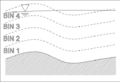
File:SMS-Particle grid data set bin elevations 101 datum bathy.png When using the bathymetry as a datum, the bins are offsets from the specified bathymetry dataset. This is useful when determining the effects of concentrations on b(577 × 393 (56 KB)) - 14:40, 17 May 2016
File:SMS-Particle grid data set bin elevations 101 datum wse.png When using the bathymetry as a datum, the bins are offsets from the specified bathymetry dataset. This is useful when determining the effects of concentrations on f(577 × 391 (51 KB)) - 14:43, 17 May 2016- #REDIRECT [[WMS:CE-QUAL-W2 Bathymetry]]39 bytes (4 words) - 15:52, 3 September 2013
- #REDIRECT [[WMS:CE-QUAL-W2 Bathymetry]]39 bytes (4 words) - 15:53, 3 September 2013
- #REDIRECT [[WMS:CE-QUAL-W2 Bathymetry]]39 bytes (4 words) - 15:53, 3 September 2013
- #REDIRECT [[WMS:CE-QUAL-W2 Bathymetry]]39 bytes (4 words) - 15:53, 3 September 2013
- #REDIRECT [[WMS:CE-QUAL-W2 Bathymetry]]39 bytes (4 words) - 15:52, 3 September 2013
- #REDIRECT [[WMS:CE-QUAL-W2 Bathymetry]]39 bytes (4 words) - 15:52, 3 September 2013
- #REDIRECT [[WMS:CE-QUAL-W2 Bathymetry]]39 bytes (4 words) - 15:52, 3 September 2013
- #REDIRECT [[WMS:CE-QUAL-W2 Bathymetry]]39 bytes (4 words) - 15:52, 3 September 2013
- #REDIRECT [[WMS:CE-QUAL-W2 Bathymetry]]39 bytes (4 words) - 15:52, 3 September 2013
- #REDIRECT [[WMS:CE-QUAL-W2 Bathymetry]]39 bytes (4 words) - 15:52, 3 September 2013
- #REDIRECT [[WMS:CE-QUAL-W2 Bathymetry]]39 bytes (4 words) - 15:52, 3 September 2013
- #REDIRECT [[SMS:Importing Bathymetry Data into SMS]]55 bytes (7 words) - 23:06, 22 July 2020
- ==Bathymetry as Datum== When using the bathymetry as a datum, the bins are offsets from the specified bathymetry dataset. This is useful when determining the effects of concentrations on b2 KB (248 words) - 17:09, 19 September 2017
File:Lake bathymetry.png adjust cell elevation for lake bathymetry(395 × 245 (8 KB)) - 16:53, 17 July 2014
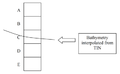
File:CEQUALW2BathymetryFig2.png The bathymetry describing the shoreline elevations on either side of the model must be kno(559 × 753 (42 KB)) - 15:11, 2 September 2014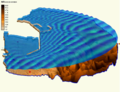
File:Functionalsurface.png Image of water surface over a model's bathymetry(780 × 600 (542 KB)) - 15:51, 17 April 2017- ...ide the land elevation if the distance between the elevation and the nodal bathymetry is less than the set value. Default is 3.0. ** ''Constant elevation, independent of nodal bathymetry'' – Set slightly lower than the minimum expected water elevation for2 KB (228 words) - 15:51, 30 July 2019
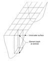
File:CEQUALW2BathymetryFig1.png ...the elevation determined from data gathered that describes the underlying bathymetry(541 × 615 (25 KB)) - 15:10, 2 September 2014


