Search results
From XMS Wiki
Jump to navigationJump to search
- ...umb|none|left|550 px|HY8 Modeling Wizard showing the ''Define Land Use and Soil Data'' step.]] The ''Define Land Use and Soil Data'' step converts GIS Module shapefiles to data in the WMS Map module.739 bytes (110 words) - 15:20, 20 October 2017
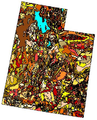
File:GSDA NRCS STATSGO Soil Type.png NRCS STATSGO soil type for the state of Utah.(343 × 426 (248 KB)) - 14:34, 1 November 2017- :A GSSHA model is needed before soil data can be added. !style="text-align:left;"|2. Add soil data.2 KB (208 words) - 17:46, 1 May 2023
File:WMS JoinTableShapefile.jpg ...ure is commonly used to join a separate table of soil attributes to a soil type shapefile in order to compute composite Curve Numbers.(738 × 558 (88 KB)) - 16:04, 9 January 2017
File:GSDA EPA Soil Type.png EPA soil type for an EPA watershed near Provo, Utah.(400 × 152 (70 KB)) - 14:32, 1 November 2017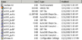
File:GSDA SHPdirectory.png ...ind several shapefiles; the shapefile containing an "_a" contains the soil type polygon shapes.(459 × 226 (6 KB)) - 15:10, 2 November 2017- ...numbers. For a [[WMS:Land Use|land use]] or [[WMS:Soil Type Coverage|soil type coverage]], the mapping table may be set up interactively by selecting each ...le is a mapping table containing composite curve numbers (CN), which are a type of lumped parameter. Land use tables with corresponding CNs vary from text2 KB (290 words) - 00:27, 21 December 2019
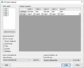
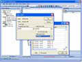
File:SoilAtts.png Soil Type Mapping dialog(652 × 528 (13 KB)) - 18:45, 5 January 2024- ...ure is commonly used to join a separate table of soil attributes to a soil type shapefile in order to compute composite Curve Numbers.578 bytes (90 words) - 15:52, 11 April 2017
- ...s in the United States. Information covered includes soil characteristics, soil properties, and addresses limits, risks, and suitability for various uses. ...=https://websoilsurvey.sc.egov.usda.gov/App/WebSoilSurvey.aspx |title= Web Soil Survey |accessdate=May 1, 2019 |publisher=USDA Natural Resource Conservatio4 KB (572 words) - 21:11, 1 May 2019
- ...Dialog GSSHA Overland Soil Erosion.png|thumb|right|500 px|GSSHA ''Overland soil erosion'' dialog.]] ...on'' dialog allows sediments to be defined. It is accessed by turning on ''Soil erosion'' in the other options section of the [[WMS:GSSHA Job Control|''GSS4 KB (582 words) - 19:39, 17 May 2019
- ; Computing Orange County Losses : Soil type and land use data are required in order to compute Orange County losses (Fm # [[WMS:Importing Shapefiles|Import shapefiles]] with soil type and land use data2 KB (313 words) - 15:11, 16 October 2017
- ...to be imported into WMS. Digital maps of rainfall depth (isohyetal maps), soil types, land use (percent impervious), and DPA zones are all available from ===Computation Type===5 KB (871 words) - 19:52, 4 January 2024
- ...ns/gis_data/huc/ this location]. "Ssurgo" data can be downloaded from the soil data mart [http://soildatamart.nrcs.usda.gov/ here]. # If needed, convert the coordinates of the soil data to State plane coordinates as described for DEMs above.5 KB (775 words) - 20:59, 22 July 2020
- ...·}}[[WMS:GSSHA Join SSURGO Data#Using Soil Type Data with GSSHA|Using Soil Type Data with GSSHA]]2 KB (303 words) - 21:52, 21 May 2019
- .... Many, if not all, of these losses are affected by the land cover or soil type. ...ethod#OC_Rational_Equation|peak flow rate]]. This value corresponds to the soil group, cover complex, and imperviousness of the drainage subarea. ''Fm'' is1 KB (216 words) - 21:34, 21 November 2023
- * [[WMS:Soil Type|Soil Type]]1 KB (218 words) - 16:56, 1 July 2019
- #SCS (NRCS) Curve Numbers for hydrologic soil groups (requires the use of a soil coverage as well). #Soil type A CN, soil type B CN, soil type C CN, and soil type D CN.3 KB (520 words) - 15:46, 10 January 2024
- ...her number indicates a higher likelihood of the contaminant adsorbing onto soil particles. ...distribution coverage type in WMS. Simply create either a land use or soil type coverage and create polygons representing the different contaminant plumes.3 KB (497 words) - 17:10, 15 April 2019
- Most of the files used by WMS have a card type format. With this format, the different components of the file are grouped * [[WMS:Soil Type Runoff Coefficient Files|Soil Type Runoff Coefficient Files]]2 KB (290 words) - 16:44, 17 February 2014


