File:DEM Guidelines 8.jpg: Difference between revisions
From XMS Wiki
Jump to navigationJump to search
No edit summary |
No edit summary |
||
| Line 1: | Line 1: | ||
[[Category:DEM]] | [[Category:DEM]] | ||
Once the boundaries of the sub-basins have been determined geometric properties important to hydrologic modeling (area, slopes, runoff distances, etc.) can be computed from the DEM data. | |||
Revision as of 16:53, 21 August 2014
Once the boundaries of the sub-basins have been determined geometric properties important to hydrologic modeling (area, slopes, runoff distances, etc.) can be computed from the DEM data.
File history
Click on a date/time to view the file as it appeared at that time.
| Date/Time | Thumbnail | Dimensions | User | Comment | |
|---|---|---|---|---|---|
| current | ★ Approved revision 16:36, 2 February 2008 | 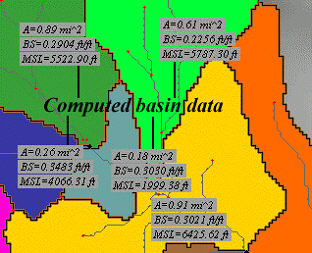 | 312 × 253 (33 KB) | Eshaw (talk | contribs) |
You cannot overwrite this file.
File usage
The following page uses this file: