File:Dem2.jpg: Difference between revisions
From XMS Wiki
Jump to navigationJump to search
No edit summary |
No edit summary |
||
| (One intermediate revision by the same user not shown) | |||
| Line 1: | Line 1: | ||
[[Category:WMS Quick Tour]] | [[Category:WMS Quick Tour]] | ||
[[Category:DEM]] | |||
Using the TOPAZ program created and distributed through the USDA, a flow direction is computed for each of the DEM cells. Flow paths can then be traced for any point on the DEM. Flow distance and slope along the path are easily determined from the DEM data. | |||
Latest revision as of 18:29, 24 May 2018
Using the TOPAZ program created and distributed through the USDA, a flow direction is computed for each of the DEM cells. Flow paths can then be traced for any point on the DEM. Flow distance and slope along the path are easily determined from the DEM data.
File history
Click on a date/time to view the file as it appeared at that time.
| Date/Time | Thumbnail | Dimensions | User | Comment | |
|---|---|---|---|---|---|
| current | ★ Approved revision 19:22, 7 June 2007 | 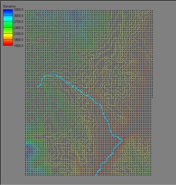 | 350 × 368 (46 KB) | Cballard (talk | contribs) |
You cannot overwrite this file.
File usage
The following page uses this file: