File:FloodplainDelineationQuick2.jpg
From XMS Wiki
Jump to navigationJump to search
No higher resolution available.
FloodplainDelineationQuick2.jpg (503 × 290 pixels, file size: 87 KB, MIME type: image/jpeg)
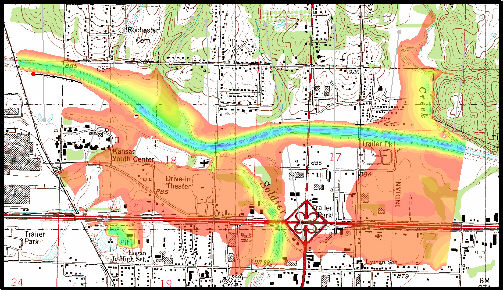
Users can create maps depicting flood extent and flood depth
File history
Click on a date/time to view the file as it appeared at that time.
| Date/Time | Thumbnail | Dimensions | User | Comment | |
|---|---|---|---|---|---|
| current | ★ Approved revision 16:51, 21 August 2007 | | 503 × 290 (87 KB) | Trabadi (talk | contribs) |
You cannot overwrite this file.
File usage
The following page uses this file: