File:Fobject1.jpg: Difference between revisions
From XMS Wiki
Jump to navigationJump to search
No edit summary |
No edit summary |
||
| Line 1: | Line 1: | ||
[[Category:WMS Quick Tour]] | [[Category:WMS Quick Tour]] | ||
[[Category:WMS Basins]] | [[Category:WMS Basins]] | ||
[[Category:WMS Feature Objects]] | |||
Feature Objects are comprised of layers of points, lines, and polygons. The primary use of these kind of data in WMS is for modeling watersheds where points represent junctions (outlets of basins), lines represent the stream network, and polygons the basin boundaries. WMS combines all three feature objects into a single coverage or layer called the drainage coverage. | Feature Objects are comprised of layers of points, lines, and polygons. The primary use of these kind of data in WMS is for modeling watersheds where points represent junctions (outlets of basins), lines represent the stream network, and polygons the basin boundaries. WMS combines all three feature objects into a single coverage or layer called the drainage coverage. | ||
Latest revision as of 16:23, 9 January 2017
Feature Objects are comprised of layers of points, lines, and polygons. The primary use of these kind of data in WMS is for modeling watersheds where points represent junctions (outlets of basins), lines represent the stream network, and polygons the basin boundaries. WMS combines all three feature objects into a single coverage or layer called the drainage coverage.
File history
Click on a date/time to view the file as it appeared at that time.
| Date/Time | Thumbnail | Dimensions | User | Comment | |
|---|---|---|---|---|---|
| current | ★ Approved revision 19:44, 7 June 2007 | 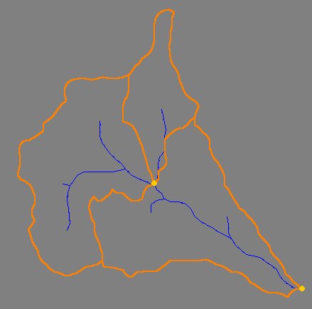 | 439 × 434 (16 KB) | Cballard (talk | contribs) |
You cannot overwrite this file.
File usage
The following page uses this file: