File:GIS Right-ClickMenu1.png: Difference between revisions
From XMS Wiki
Jump to navigationJump to search
No edit summary |
No edit summary |
||
| Line 1: | Line 1: | ||
[[Category:GIS]] | [[Category:GIS]] | ||
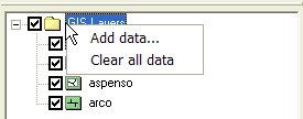
Right-clicking on the main GIS Layers folder allows a user to add the various types of GIS data (open new GIS layers) or clear all data. | |||
Revision as of 16:11, 29 August 2014
Right-clicking on the main GIS Layers folder allows a user to add the various types of GIS data (open new GIS layers) or clear all data.
File history
Click on a date/time to view the file as it appeared at that time.
| Date/Time | Thumbnail | Dimensions | User | Comment | |
|---|---|---|---|---|---|
| current | ★ Approved revision 16:19, 15 November 2016 | 275 × 108 (3 KB) | Jcreer (talk | contribs) | ||
| 19:52, 12 June 2007 | 275 × 108 (4 KB) | Cballard (talk | contribs) |
You cannot overwrite this file.
File usage
The following page uses this file: