File:GSDA TIN Elevations.png: Difference between revisions
From XMS Wiki
Jump to navigationJump to search
No edit summary |
No edit summary |
||
| (3 intermediate revisions by the same user not shown) | |||
| Line 1: | Line 1: | ||
[[Category:GSDA]] | [[Category:GSDA]] | ||
[[Category:TINs]] | |||
[[Category:Images]] | |||
Elevations are then interpolated along the face of each triangle, allowing contours to be drawn. | |||
Latest revision as of 15:07, 1 November 2017
Elevations are then interpolated along the face of each triangle, allowing contours to be drawn.
File history
Click on a date/time to view the file as it appeared at that time.
| Date/Time | Thumbnail | Dimensions | User | Comment | |
|---|---|---|---|---|---|
| current | ★ Approved revision 19:47, 21 May 2008 | 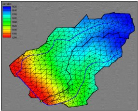 | 286 × 229 (111 KB) | Eshaw (talk | contribs) |
You cannot overwrite this file.
File usage
The following page uses this file: