File:Hspfbasins.jpg: Difference between revisions
From XMS Wiki
Jump to navigationJump to search
No edit summary |
No edit summary |
||
| (One intermediate revision by the same user not shown) | |||
| Line 1: | Line 1: | ||
[[Category:WMS Quick Tour]] | [[Category:WMS Quick Tour]] | ||
[[Category:HSPF]] | |||
[[Category:WMS Basins]] | |||
There is a comprehensive interface to HSPF, the EPA's hydrologic model of choice for development of TMDLs. As part of the interface WMS automates segmentation of basins from polygons of land use and/or soil. | |||
Latest revision as of 16:19, 6 January 2017
There is a comprehensive interface to HSPF, the EPA's hydrologic model of choice for development of TMDLs. As part of the interface WMS automates segmentation of basins from polygons of land use and/or soil.
File history
Click on a date/time to view the file as it appeared at that time.
| Date/Time | Thumbnail | Dimensions | User | Comment | |
|---|---|---|---|---|---|
| current | ★ Approved revision 17:36, 20 August 2007 | 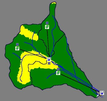 | 350 × 331 (19 KB) | Trabadi (talk | contribs) |
You cannot overwrite this file.
File usage
The following page uses this file: