File:WMS DEM TrimArea.png: Difference between revisions
From XMS Wiki
Jump to navigationJump to search
No edit summary |
(Jcreer uploaded a new version of File:WMS DEM TrimArea.png) |
| (One intermediate revision by the same user not shown) | |
(No difference)
| |
Latest revision as of 15:41, 21 November 2017
If a polygon is already selected prior to choosing the Trim command then the selected polygon will be used for trimming without a prompt. When trimming with a polygon, only the DEM points within the polygon will have active elevations as everything outside the polygon, but within the bounding rectangle of the polygon is set to a NODATA value
File history
Click on a date/time to view the file as it appeared at that time.
| Date/Time | Thumbnail | Dimensions | User | Comment | |
|---|---|---|---|---|---|
| current | ★ Approved revision 15:41, 21 November 2017 | 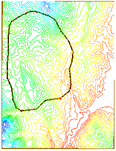 | 229 × 297 (68 KB) | Jcreer (talk | contribs) | |
| 23:32, 3 October 2008 | No thumbnail | 229 × 297 (68 KB) | Eshaw (talk | contribs) |
You cannot overwrite this file.
File usage
The following 2 pages use this file:
- File:WMSImage272.png (file redirect)
- WMS:Editing DEMs