Search results
From XMS Wiki
Jump to navigationJump to search
Page title matches
- ===Arcs to Polygons=== The ''Arcs to Polygons'' tool converts all arcs in a coverage to polygons based on specified parameters.7 KB (1,087 words) - 18:47, 25 October 2023
- {{Arcs to Polygons}}66 bytes (9 words) - 21:31, 1 May 2024
Page text matches
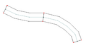
File:EndToEndArcs.png Arc to Polygons tool in the Toolbox Example 5 Two arcs connected end to end converted to polygons(1,012 × 570 (10 KB)) - 19:45, 25 October 2023- :Polygons are not created automatically when arcs are enclosed. To create polygons: :# Use the [[GMS:Feature Object Commands|''Feature Objects'' | '''Build Polygons''']] command.<noinclude>[[Category:GMS Workflow Templates|build]]</noinclud242 bytes (30 words) - 17:52, 24 March 2016
- ...polygons. The user also specifies a buffer distance to allow the trimming to not retain the intersection points ...sired simulation domain. Another application would be to clear out feature arcs that are inside the extents of a predominant feature such as a main river c2 KB (380 words) - 20:06, 25 October 2023
- :Polygons are not created automatically when arcs are enclosed. To create polygons: :# Use the [[WMS:Feature Objects Menu|''Feature Objects'' | '''Build Polygons''']] command.<noinclude>[[Category:WMS Workflow Templates|build]]</noinclud239 bytes (30 words) - 21:36, 13 November 2019
- :Polygons are not created automatically when arcs are enclosed. To create polygons: :# Use the [[SMS:Map Feature Objects Menu|''Feature Objects'' | '''Build Polygons''']] command.<noinclude>[[Category:SMS Workflow Templates|build]]</noinclud243 bytes (31 words) - 20:31, 25 March 2016
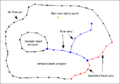
File:Concmod.png ...type, parameters such as head, concentration and conductance are assigned to these feature objects.(436 × 304 (3 KB)) - 14:46, 21 April 2016- ...pose of this inundation polygon is to compute a storage capacity curve and to define a flood barrier when running the floodplain delineation. ...undation boundary. Normally, use the roadway as one of the arcs and build arcs for the rest of the inundation boundary.2 KB (233 words) - 19:31, 4 May 2020
- ...forming the boundary of the polygon. All closed loops will be formed into polygons. ...e defining material zones or creating meshes from a coverage, the '''Build Polygons''' command must be used.1 KB (241 words) - 18:33, 15 July 2016
- ...age. Nodes that are within the polygons or located a specified distance of arcs will be assigned the value 1.0 ("locked") and all other nodes will be assig ...coverage'' – Select the coverage that contains the polygons or arcs to be used for specifying locked nodes.1 KB (183 words) - 21:04, 12 December 2023
- ...SMS:toolbox|SMS toolbox]] designed to perform specialized modifications to to feature objects inside [[SMS:Coverages|coverages]]. {{Polygons from Arcs}}405 bytes (50 words) - 19:53, 25 October 2023
- ===UGrid Boundary to Polygons=== ...UGrid Boundary to Polygons tool converts the outer boundary of a UGrid to polygons in a new coverage. This tool only functions on UGrids with 2D Cells.894 bytes (132 words) - 20:07, 25 October 2023
- {{Arcs to Polygons}}66 bytes (9 words) - 21:31, 1 May 2024
- ...SMS:toolbox|SMS toolbox]] designed to perform specialized modifications to to feature objects inside [[SMS:Coverages|coverages]]. {{Polygons from Arcs}}471 bytes (58 words) - 19:51, 25 October 2023
- ===Polygons from UGrid Boundary=== ...olygons from UGrid Boundary tool converts the outer boundary of a UGrid to polygons in a new coverage. This tool only functions on UGrids with 2D Cells.900 bytes (132 words) - 20:00, 25 October 2023
- ...SMS:toolbox|SMS toolbox]] designed to perform specialized modifications to to feature objects inside [[SMS:Coverages|coverages]]. {{Polygons from Arcs}}494 bytes (59 words) - 20:00, 26 October 2023
- :#Switch to the [[SMS:SRH-2D_Coverages#Boundary_Conditions_Coverage|SRH-2D materials]] ...|16 px]] tool, create arcs for the enclosed area between the two structure arcs.817 bytes (116 words) - 14:50, 26 June 2017
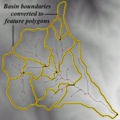
File:DEM Guidelines 7.jpg ...es between DEM points with different basin IDs can be converted to feature polygons. Storing a basin as a single polygon rather than several hundreds (or thous(377 × 378 (53 KB)) - 16:19, 7 December 2016- ...emely redundant, meaning that points or lines that are shared by lines or polygons are multiply defined. ...that the new GIS module has been developed and with or without a license to ArcObjects® shapefile data can now be managed better by SMS.3 KB (416 words) - 19:22, 24 August 2017
- ...he use of feature objects is determined by the coverage, or attribute set, to which they belong, but can be separated into three important categories: #As a means of defining basin polygons and stream networks of pre-delineated watersheds (typically this data would5 KB (734 words) - 15:36, 28 September 2017
- TINs may be converted to other types of data used in GMS, such as a 2D mesh or 2D scatter points. TI ...each triangle in the TIN. Any datasets associated with the TIN are copied to the new mesh.2 KB (306 words) - 14:53, 24 October 2017


