Search results
From XMS Wiki
Jump to navigationJump to search
Page title matches
- ...e recalled later without having to perform the same processing steps. The DEM file format is shown in Figure 1 and a sample file is shown in Figure 2. |DEM||/* File type identifier */4 KB (505 words) - 16:27, 15 January 2016
- 41 bytes (5 words) - 18:17, 28 August 2013
Page text matches
- Files and articles related to DEM dialogs [[Category:DEM]]18 members (0 subcategories, 10 files) - 16:52, 10 December 2015
- #REDIRECT [[WMS:DEM Files]]27 bytes (4 words) - 17:40, 26 July 2013
- #REDIRECT [[WMS:DEM Files]]27 bytes (4 words) - 17:40, 26 July 2013
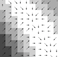
File:DEM Guidelines 2.png [[Category:DEM]] ...rom the flow directions, or read from ARC/INFO®, GRASS, or TOPAZ formatted files.(377 × 367 (72 KB)) - 16:02, 9 June 2016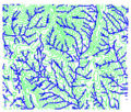
File:DEM Guidelines 3.jpg [[Category:DEM]] ...rom the flow directions, or read from ARC/INFO®, GRASS, or TOPAZ formatted files.(284 × 241 (74 KB)) - 16:55, 21 August 2014- ...e files native to (determined by) WMS can be accessed from the list below. Files which are used by analysis codes such as HEC-1 are not documented here sinc Most of the files used by WMS have a card type format. With this format, the different compon2 KB (290 words) - 16:44, 17 February 2014
- !style="text-align:left;"|1. Import DEM files. ...Menu|'''Open''']] command to import raster data files such as DEMs, [[KMZ files]], and gridded elevation formats.1 KB (195 words) - 20:58, 9 December 2019
- !style="text-align:left;"|1. Import DEM. {{WMS Import DEM Workflow}}1 KB (175 words) - 22:20, 9 December 2019
- [[Image:WMS DEM Trim by Elevation.png|thumb|225 px|''DEM Trim by Elevation'' dialog]] ...draulic model so it is convenient to be able to trim away the parts of the DEM that are not needed.3 KB (417 words) - 16:59, 9 August 2022
- ...integer value for each DEM point that represents the number of “upstream” DEM points whose flow path passes through it. High accumulation values indicate ...ing DEM points has the lowest elevation. The flow direction value for that DEM point is then assigned an integer number representing the given direction.3 KB (489 words) - 23:30, 16 December 2019
- ...iles such as DXF, and HEC-1 files can be included in order to maintain all files pertaining to a given project together. ...iles such as DXF, and HEC-1 files can be included in order to maintain all files pertaining to a given project together.2 KB (391 words) - 15:19, 16 September 2014
- DEM files can be converted by WMS into TINs or feature objects. ===All DEM Points===3 KB (450 words) - 22:42, 17 December 2019
- ...import many files generated by other software in their native format. The files that can be imported to GMS are shown in the tables below. Each file type ...ening the super file will import the entire model and all associated model files. This will NOT open any GMS specific data, such as Map data or TIN data et2 KB (354 words) - 22:11, 1 May 2017
File:Tin1.jpg ...p in the process is to obtain elevation data. Elevations can come from DEM files, digitized data, or any other scattered xyz data source.(350 × 368 (26 KB)) - 15:55, 6 January 2017- ...e recalled later without having to perform the same processing steps. The DEM file format is shown in Figure 1 and a sample file is shown in Figure 2. |DEM||/* File type identifier */4 KB (505 words) - 16:27, 15 January 2016
- ...ed in the small graphics window in the center of the dialog. As additional files are added the graphics region is updated with new rectangles in order to pr ...f the DEM files which have been added to this point. By default when a new DEM file is added the bounding rectangle is adjusted to enclose all DEMs.5 KB (785 words) - 22:32, 16 December 2019
- ...ed in the small graphics window in the center of the dialog. As additional files are added the graphics region is updated with new rectangles in order to pr ...f the DEM files which have been added to this point. By default when a new DEM file is added the bounding rectangle is adjusted to enclose all DEMs.5 KB (794 words) - 22:32, 16 December 2019
- ...r use in basin delineation with DEMs. However, TOPAZ is capable of further DEM elevation processing, including raster smoothing, basin and stream delineat ...Modeling Wizard'']], the '''Compute TOPAZ''' command will save the current DEM elevations to a TOPAZ formatted input file along with a TOPAZ control file4 KB (558 words) - 18:47, 8 November 2023
- ...p in the process is to obtain elevation data. Elevations can come from DEM files, digitized data, or any other scattered xyz data source.491 bytes (73 words) - 15:49, 11 April 2017
- :#Use [[WMS:File Menu|''File'' | '''Open...''']] to open files with TIN, DEM, or scatter data.375 bytes (60 words) - 22:25, 5 December 2019


