WMS:Importing Flow Directions and Accumulations
A flow direction grid consists of a flow direction value for each DEM point. The flow direction identifies which neighboring point has the lowest elevation. A flow accumulation grid consists of an integer value for each DEM point that represents the number of “upstream” DEM points whose flow path passes through it. High accumulation values indicate points in the stream, whereas low values represent areas of overland flow.
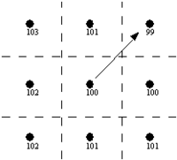
Flow directions and accumulations are typically determined using a program, such as ArcView®, GRASS, or TOPAZ. Resulting grid files can then be imported into WMS. These programs all use variations of the eight-point pour model (see References). The figure below illustrates how flow directions are computed by determining which of the eight neighboring DEM points has the lowest elevation. The flow direction value for that DEM point is then assigned an integer number representing the given direction.
Eight-Point Pour Model.
If all DEM points had one and only one lower neighbor, the process of determining flow directions would be simple and the requirement to use other programs would not exist. However, there are many subtle problems dealing with depressions and flat areas which make the algorithm for determining flow directions complex. Computation of flow accumulations are fairly straight-forward once the flow directions are determined.
At this point computations of flow directions can not be done directly by WMS. However, a version of the TOPAZ program, modified specifically to work with WMS, creates as output the flow direction and flow accumulation grids. These grids can then be imported as DEM attributes and used for basin delineation.
Besides TOPAZ, flow directions may also be computed by ARC/INFO®, ArcView®, or GRASS. No matter which program being used to create flow directions, import them using the Import Flow Directions/Accumulations command. If using TOPAZ, the file will always be named FLOVEC.DAT for flow directions and UPAREA.DAT for flow accumulations. WMS automatically reads these files when the TOPAZ computations are complete.
Flow accumulations are computed by counting, for each DEM point, the number of DEM points whose flow paths pass through the DEM point, and then represented as accumulated area (area of a DEM cell times the number of upstream DEM cells). Streams will be identified by large accumulation values since the flow paths of many points pass through the stream points. For example the outlet of a watershed should have the highest flow accumulation of any of the DEM points since the flow paths all points in the watershed will eventually pass through the outlet point. Flow accumulations may also be imported as a result of using one of the other GIS programs previously mentioned.
Related Topics
| [hide] WMS – Watershed Modeling System | ||
|---|---|---|
| Modules: | Terrain Data • Drainage • Map • Hydrologic Modeling • River • GIS • 2D Grid • 2D Scatter |  |
| Models: | CE-QUAL-W2 • GSSHA • HEC-1 • HEC-HMS • HEC-RAS • HSPF • MODRAT • NSS • OC Hydrograph • OC Rational • Rational • River Tools • Storm Drain • SMPDBK • SWMM • TR-20 • TR-55 | |
| Toolbars: | Modules • Macros • Units • Digitize • Static Tools • Dynamic Tools • Drawing • Get Data Tools | |
| Aquaveo | ||
