Search results
From XMS Wiki
Jump to navigationJump to search
Page title matches
- ...ta such as a [http://trac.osgeo.org/geotiff/ GeoTIFF], are referred to as "rasters". GMS supports a large number of DEM formats. After importing, DEMs are lis ==Importing Rasters==3 KB (425 words) - 20:16, 24 May 2022
- #redirect [[GMS:Rasters]]25 bytes (3 words) - 17:12, 4 May 2017
- Category for tools and tool templates that are part of the Rasters folder in the Toolbox.50 members (0 subcategories, 11 files) - 19:04, 23 February 2024
- #redirect [[GMS:Rasters]]25 bytes (3 words) - 17:12, 4 May 2017
- #redirect [[GMS:Rasters]]25 bytes (3 words) - 17:13, 4 May 2017
- ...:toolbox|SMS toolbox]] that are used to edit, create, and otherwise modify rasters. ==Rasters Tools==554 bytes (68 words) - 19:38, 26 October 2023
- 28 bytes (3 words) - 21:47, 17 June 2013
- 28 bytes (3 words) - 21:48, 17 June 2013
- [[File:ArcGIS Pro Rasters to GeoSections.png|350px|thumb|right|''Rasters to GeoSections'' tool in the ''Geoprocessing'' pane]] ...s accessed by double-clicking on "[[File:ArcGISPro Toolbx Tool.png|16 px]] Rasters to GeoSections" under the "[[File:ArcGISPro Toolset.png|16 px]] Features" t4 KB (672 words) - 16:54, 14 April 2023
- To use rasters to generate solids, use the following steps: {{Horizons with Rasters Workflow}}195 bytes (24 words) - 16:53, 24 January 2017
- [[File:ArcGIS Pro Rasters to GeoVolumes.png|350px|thumb|right|''Rasters to GeoVolumes'' tool in the ''Geoprocessing'' pane]] ...s accessed by double-clicking on "[[File:ArcGISPro Toolbx Tool.png|16 px]] Rasters to GeoVolumes" under the "[[File:ArcGISPro Toolset.png|16 px]] Features" to5 KB (722 words) - 16:54, 14 April 2023
- 1 KB (181 words) - 16:14, 21 February 2017
- #redirect [[Horizons with Rasters Workflow]]44 bytes (5 words) - 16:19, 24 January 2017
- ===Interpolate Priority Rasters=== ...elected geometry (UGrid/Mesh2D/Scatter Set) by interpolating from multiple rasters according to a user specified priority. Each source is added to the list in4 KB (525 words) - 19:06, 26 October 2023
- ===Merge Elevation Rasters=== ...ation Rasters'' tool creates a new raster by merging two or more elevation rasters with priority into a new raster.2 KB (276 words) - 19:08, 26 October 2023
- ===3D UGrid from Rasters=== ...ids|2D UGrid]] by extruding the 2D UGrid and creating layers inbetween the rasters using the [[GMS:Horizons|horizons]] approach. The resulting UGrid will be "4 KB (556 words) - 22:30, 23 October 2023
- {{Merge Elevation Rasters}} [[Category:Toolbox Rasters]]73 bytes (8 words) - 19:10, 26 October 2023
- {{Interpolate Priority Rasters}} [[Category:Toolbox Rasters]]78 bytes (8 words) - 19:06, 26 October 2023
- 26 bytes (3 words) - 16:07, 8 October 2013
- ...:Toolbox|SMS Toolbox]] that are used to edit, create, and otherwise modify rasters. ==Rasters Tools==567 bytes (70 words) - 20:08, 26 October 2023
Page text matches
- == 13.3 Rasters Tools == ...:toolbox|SMS toolbox]] that are used to edit, create, and otherwise modify rasters.570 bytes (69 words) - 20:00, 26 October 2023
- ...:toolbox|SMS toolbox]] that are used to edit, create, and otherwise modify rasters. ==Rasters Tools==554 bytes (68 words) - 19:38, 26 October 2023
- ...:Toolbox|SMS Toolbox]] that are used to edit, create, and otherwise modify rasters. ==Rasters Tools==567 bytes (70 words) - 20:08, 26 October 2023
- {{Merge Elevation Rasters}} [[Category:Toolbox Rasters]]73 bytes (8 words) - 19:10, 26 October 2023
- {{Interpolate Priority Rasters}} [[Category:Toolbox Rasters]]78 bytes (8 words) - 19:06, 26 October 2023
- To use rasters to generate solids, use the following steps: {{Horizons with Rasters Workflow}}195 bytes (24 words) - 16:53, 24 January 2017
- ===Merge Elevation Rasters=== ...ation Rasters'' tool creates a new raster by merging two or more elevation rasters with priority into a new raster.2 KB (276 words) - 19:08, 26 October 2023
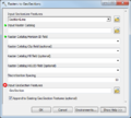
File:AHGW Subsurface Analyst Features - Rasters to GeoSections.png The [[AHGW:Rasters to GeoSections|''Rasters to GeoSections'' dialog]] in [[AHGW:AHGW|Arc Hydro Groundwater]].(486 × 438 (34 KB)) - 00:03, 29 August 2019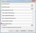
File:AHGW Subsurface Analyst Features - Rasters to GeoVolumes.png The [[AHGW:Rasters to GeoVolumes|''Rasters to GeoVolumes'' dialog]] in [[AHGW:AHGW|Arc Hydro Groundwater]].(486 × 440 (32 KB)) - 00:11, 29 August 2019- ...ta such as a [http://trac.osgeo.org/geotiff/ GeoTIFF], are referred to as "rasters". GMS supports a large number of DEM formats. After importing, DEMs are lis ==Importing Rasters==3 KB (425 words) - 20:16, 24 May 2022
- #redirect [[GMS:Rasters]]25 bytes (3 words) - 17:12, 4 May 2017
- #redirect [[GMS:Rasters]]25 bytes (3 words) - 17:12, 4 May 2017
- #redirect [[GMS:Rasters]]25 bytes (3 words) - 17:12, 4 May 2017
- #REDIRECT [[Rasters Tools]]27 bytes (3 words) - 19:50, 31 January 2022
- #redirect [[GMS:Rasters]]25 bytes (3 words) - 17:13, 4 May 2017
- #redirect [[GMS:Rasters]]25 bytes (3 words) - 17:13, 4 May 2017
- #redirect [[GMS:Rasters]]25 bytes (3 words) - 17:13, 4 May 2017
- #redirect [[GMS:Rasters]]25 bytes (3 words) - 17:07, 4 May 2017
- #redirect [[GMS:Rasters]]25 bytes (3 words) - 17:07, 4 May 2017
- #redirect [[Horizons with Rasters Workflow]]44 bytes (5 words) - 16:19, 24 January 2017

