Template:Extend Raster: Difference between revisions
From XMS Wiki
Jump to navigationJump to search
(Created page with "__NOINDEX__ __NOTOC__ ===Extend to Polygon=== The ''Extend to Polygon'' tool creates a new raster from an existing raster and a coverage with a polygon. The polygons in the...") |
No edit summary |
||
| (8 intermediate revisions by 3 users not shown) | |||
| Line 1: | Line 1: | ||
__NOINDEX__ | __NOINDEX__ | ||
__NOTOC__ | __NOTOC__ | ||
===Extend | ===Extend Raster=== | ||
The ''Extend | The ''Extend Raster'' tool creates a new raster from an existing raster and a coverage with a polygon. The polygons in the coverage extend the active region of the input raster, with the elevation values of the polygons being used to assign elevation values on the raster. Elevation values from the polygon’s nodes and vertices will be used to assign elevation values to the raster on the edges of the polygon. Any gaps or spaces in between the input raster and the polygons in the coverage will be filled in by interpolation. NODATA values inside of the polygon will also be filled in by interpolation. | ||
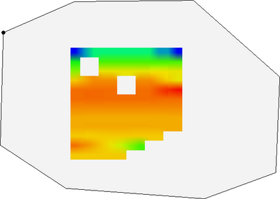
:[[File:ExtendtoPolygon1.png|thumb|none|400 px|Original raster (containing NODATA holes) and polygon to extend to.]] | |||
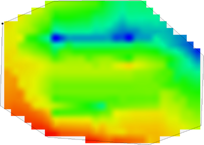
Original raster (containing NODATA holes) and polygon to extend to. | :[[File:ExtendtoPolygon2.png|thumb|none|400 px|Raster extended to polygon using elevation values from the polygon.]] | ||
====Input Parameters==== | |||
Raster extended to polygon using elevation values from the polygon. | *''Input raster'' – The raster for which the active boundary polygon will be created. | ||
====Input | *''Coverage with polygons'' – A coverage with a polygon that the input raster will be extended to. The polygon should have elevation values that will be assigned to the output raster. | ||
*Input raster | |||
*Coverage with | ====Output Parameters==== | ||
====Output | *''Output raster'' – The new raster created from the input raster and polygons.. | ||
*Output raster | ====Current Location in Toolbox==== | ||
====Current Location in | |||
Rasters/Bounds to Polygon | Rasters/Bounds to Polygon | ||
====Related Tools==== | ====Related Tools==== | ||
*Rasters/Trim Raster | *Rasters/Trim Raster | ||
<noinclude>[[Category: | <noinclude>[[Category:Toolbox Rasters]]</noinclude> | ||
Latest revision as of 19:02, 26 October 2023
Extend Raster
The Extend Raster tool creates a new raster from an existing raster and a coverage with a polygon. The polygons in the coverage extend the active region of the input raster, with the elevation values of the polygons being used to assign elevation values on the raster. Elevation values from the polygon’s nodes and vertices will be used to assign elevation values to the raster on the edges of the polygon. Any gaps or spaces in between the input raster and the polygons in the coverage will be filled in by interpolation. NODATA values inside of the polygon will also be filled in by interpolation.
Input Parameters
- Input raster – The raster for which the active boundary polygon will be created.
- Coverage with polygons – A coverage with a polygon that the input raster will be extended to. The polygon should have elevation values that will be assigned to the output raster.
Output Parameters
- Output raster – The new raster created from the input raster and polygons..
Current Location in Toolbox
Rasters/Bounds to Polygon
Related Tools
- Rasters/Trim Raster

