Search results
From XMS Wiki
Jump to navigationJump to search
Page title matches
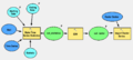
File:AHGW using the Time Series Statistics tool with the Import Raster Series tool - model example.png ...s Statistics'' tool]] with the [[AHGW:Add to Raster Series|''Add to Raster Series'' tool]] from [[AHGW:AHGW|Arc Hydro Groundwater]].(1,618 × 730 (90 KB)) - 23:31, 5 November 2019File:AHGW using the Time Series Statistics tool with the Import Raster Series tool - model example.jpg ...T [[File:AHGW using the Time Series Statistics tool with the Import Raster Series tool - model example.png]](1,618 × 730 (90 KB)) - 23:31, 5 November 2019- The time series is similar to the [[XY_Series_Editor|XY series]] with a few differences. # Times series can support more than 2 columns of data.4 KB (650 words) - 16:31, 10 March 2017
- 29 bytes (4 words) - 15:44, 4 November 2013
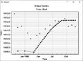
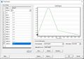
File:Time series plot.jpg Example of a time series plot.(608 × 448 (61 KB)) - 21:09, 12 April 2022- ...', found in the [[SMS:Display Menu|''Display'']] menu, and selecting "Time Series" from the plot type list in Step 1 of the [[SMS:Plot_Window#Plot_Wizard|''P == Time Series Plot Options ==4 KB (665 words) - 21:44, 14 April 2022
- ...] editor and include [[SMS:ADH_Time_Series#ADH_Time_Series_Attributes|time series attributes]] specific to ADH. The following table describes the groups: |Time offset with depth measurement (L)6 KB (951 words) - 20:13, 11 September 2023
- ...om the drop-down, indicate which Time-Array Series is being applied in the Series: field. ...RAY SERIES" – Is not supported for IEVT, SURFACE, or DEPTH. The Time-Array Series is only accessible through the Rate option in the PERIODS section.498 bytes (66 words) - 16:37, 6 June 2022
- #REDIRECT [[SMS:Time Series]]29 bytes (4 words) - 15:18, 17 June 2013
- #redirect [[SMS:Time Series Plot]]34 bytes (5 words) - 20:01, 13 October 2015
- 29 bytes (4 words) - 15:44, 4 November 2013
- ...S. It is a simple ASCII file format that defines the type of data and its time reference. Series Type Curve Name NCols NVals Reference Date<br>2 KB (146 words) - 17:47, 16 December 2014
- ...e:ArcGIS Pro Make Time Series Statistics.png|thumb|300px|right|''Make Time Series Statistics'' tool in the ''Geoprocessing'' pane]] ...statistics (e.g., mean, max, min) of the related time series over a given time period.6 KB (905 words) - 21:44, 13 April 2023
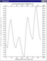
File:AHGW Time Series example.png Time Series example from [[AHGW:AHGW|Arc Hydro Groundwater]].(340 × 192 (50 KB)) - 22:21, 2 January 2020- 60 bytes (9 words) - 16:29, 10 March 2017
- #REDIRECT [[SMS:Time Series]]29 bytes (4 words) - 15:27, 17 June 2013
- 61 bytes (9 words) - 16:43, 25 February 2016
- [[File:ArcGIS Pro Time Series Grapher.png|thumb|350px|right|The ''Time Series Grapher'' pane]] ...GIS Pro, the ''Time Series Grapher'' tool is accessed by selecting '''Time Series Grapher''' from the ''Arc Hydro Groundwater'' ribbon.4 KB (588 words) - 18:56, 14 April 2023
- #REDIRECT [[SMS:Time Series]]29 bytes (4 words) - 15:37, 17 June 2013
- #REDIRECT [[SMS:Time Series Plot]]34 bytes (5 words) - 17:47, 17 September 2013


Page text matches
File:TimeSeriesCalculator.png Time Series Calculator in the Time Series Editor(488 × 535 (48 KB)) - 16:25, 8 December 2015- ...om the drop-down, indicate which Time-Array Series is being applied in the Series: field. ...RAY SERIES" – Is not supported for IEVT, SURFACE, or DEPTH. The Time-Array Series is only accessible through the Rate option in the PERIODS section.498 bytes (66 words) - 16:37, 6 June 2022
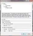
File:TimeSeriesEditor.jpg Time Series Dialog or Time Series Editor(766 × 542 (104 KB)) - 21:10, 21 June 2023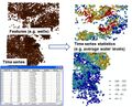
File:AHGW using the Time Series Statistics tool with example results.jpg ...and results from using the [[AHGW:Make Time Series Statistics|''Make Time Series Statistics'' tool]] from [[AHGW:AHGW|Arc Hydro Groundwater]].(766 × 616 (144 KB)) - 17:32, 22 August 2019- ==Time Series Files Dialog== [[File:MF6-TimeSeriesFiles.png|thumb|250px|right|The ''Time Series Files'' dialog]]1 KB (178 words) - 20:47, 15 March 2022

File:Time.png ...tational Time Steps Defined Using the Variable Time Step Option and the XY Series Editor.(458 × 213 (900 bytes)) - 14:14, 2 May 2016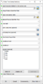
File:AHGW Make Time Series Statistics dialog.png The [[AHGW:Make Time Series Statistics|''Make Time Series Statistics'' dialog]] from [[AHGW:AHGW|Arc Hydro Groundwater]].(377 × 743 (22 KB)) - 22:09, 5 November 2019- ==Time-Array Series Files Dialog== [[File:MF6-TimeArraySeriesFiles.png|thumb|250px|right|The ''Time-Array Series Files'' dialog]]1 KB (176 words) - 20:47, 15 March 2022
File:WDMdataset.jpg ...input time series data from WDM files as well as the resulting output time series files.(350 × 446 (29 KB)) - 15:29, 10 January 2017File:AHGW using the Time Series Statistics tool with the Import Raster Series tool - model example.png ...s Statistics'' tool]] with the [[AHGW:Add to Raster Series|''Add to Raster Series'' tool]] from [[AHGW:AHGW|Arc Hydro Groundwater]].(1,618 × 730 (90 KB)) - 23:31, 5 November 2019- :#Select the [[SMS:Time Series Plot|"Time Series"]] option on the left and click '''Next'''. ...oinclude>[[Category:SMS Plot Workflow Templates|time]][[Category:SMS Plots|time]]</noinclude>446 bytes (64 words) - 15:28, 2 September 2016
- ...ging symbology of layers in Map and Scene views, mapping and plotting time series, and creating common products such as water level, water quality, and flow *[[AHGW:Add to Raster Series|Add to Raster Series]]1 KB (192 words) - 17:00, 11 August 2022
- ...ase, managing symbology of layers in ArcGIS Pro, mapping and plotting time series, and creating common products such as water level, water quality, and flow ...atistics'' tool is not categorized under the ''Groundwater Analyst | Time Series'' toolset in older versions of ArcGIS. It is simply categorized under the '2 KB (226 words) - 19:29, 14 April 2023
- ...ase, managing symbology of layers in ArcGIS Pro, mapping and plotting time series, and creating common products such as water level, water quality, and flow ...atistics'' tool is not categorized under the ''Groundwater Analyst | Time Series'' toolset in older versions of ArcGIS. It is simply categorized under the '2 KB (227 words) - 23:20, 12 December 2022
File:AHGW using the Time Series Statistics tool with the Import Raster Series tool - model example.jpg ...T [[File:AHGW using the Time Series Statistics tool with the Import Raster Series tool - model example.png]](1,618 × 730 (90 KB)) - 23:31, 5 November 2019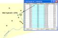
File:AHGW TimeSeries Grapher1.png Example of using the [[AHGW:Time Series Grapher Setup|''Time Series Grapher Setup'' tool]] in [[AHGW:AHGW|Arc Hydro Groundwater]].(680 × 449 (28 KB)) - 19:31, 27 August 2019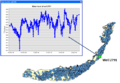
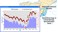
File:AHGW TimeSeries Grapher2.png Example results from using the [[AHGW:Time Series Grapher Setup|''Time Series Grapher Setup'' tool]] in [[AHGW:AHGW|Arc Hydro Groundwater]].(489 × 339 (22 KB)) - 19:31, 27 August 2019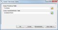
File:Create Time Series Tables dialog.png The [[AHGW:Create Time Series Tables|''Create Time Series Tables'' dialog]] in [[AHGW:AHGW|Arc Hydro Groundwater]].(513 × 264 (22 KB)) - 19:09, 27 August 2019- ...his data can include precipitation, discharge, and other parameters versus time or other data such as elevation-area and elevation-discharge curves. [[Image:WMS XY SeriesEditor.jpg|thumb|none|left|600 px|Example of the ''XY Series Editor'' dialog.]]994 bytes (156 words) - 15:45, 28 September 2017
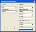
File:AHGW Time Series Grapher Setup dialog.jpg The [[AHGW:Time Series Grapher Setup|''Time Series Grapher Setup'' dialog]] in [[AHGW:AHGW|Arc Hydro Groundwater]].(427 × 385 (27 KB)) - 22:15, 2 January 2020


