There are two main projection dialogs used in SMS, GMS< and WMS: The Display Projection dialog, and the Object Projection dialog. From each of these, the Select Projection dialog can be accessed. More detailed information about each projection and the information in these dialogs can be found in the Projections article.
Display Projection Dialog
The Display Projection dialog contains settings which are applied to the project as a whole.
Horizontal section
The Horizontal section of the dialog has two options available via radio buttons:
- No projection - This option doesn't set a projection, and only allows adjusting the horizontal Units used in the project. The available units include:
- "U. S. Survey Feet". Equal to 1200⁄3937 meters, approximately 0.3048006096 meters.
- "International Feet". Equal to 0.3048 meters.
- "Meters". Equal to the distance traveled by light in vacuum within 1⁄299792458 of a second.
- "Inches". Equal to 1⁄39.37 of a meter.
- "Centimeters". Equal to 1⁄100 of a meter.
- Global projection - Clicking on the Set Projection button allows more specific projections to be set. These are listed below in the Select Projection Dialog section.
Vertical section
The Vertical section has two drop-down boxes:
- Projection, giving the following options:
- Units, giving the following options:
- "U. S. Survey Feet"
- "International Feet"
- "Meters"
- "Inches"
- "Centimeters"
Object Projection Dialog
The Object Projection dialog is the same as the Display Projection dialog, but only applies to one specific object (e.g., a coverage or a mesh). It can be accessed by selecting the object in the Project Explorer, then right-clicking on it and selecting Projection... from the menu.
Select Projection Dialog
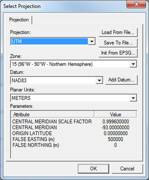
The
Select Projection dialog.
The Select Projection dialog is accessed through the Set Projection... button in either the Display Projection dialog or the Object Projection dialog. It allows setting global projections for the project or for a specific object. It contains a single Projection tab with several options and sections.
All lists of drop-down selections are given in the order in which they appear in the drop-down.
Projection and Zone
There are many options available from the Projection drop-down:
To the right of the Projection drop-down are three buttons:
- Load From File...: Allows a projection to be loaded from an external file. The accepted file formats are PRJ and SPR (PRJ is preferable).
- Save to File...: Allows the projection information set in this dialog to be saved as a PRJ file.
- Init from EPSG...: Opens a dialog where an EPSG Projection Code can be entered.
Datum
Datums in italics are placeholders for the collapsed list directly below that entry.
Create New Datum dialog
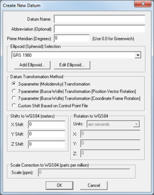
The
Create New Datum dialog which appears when the
Add Datum... button is clicked in the
Select Projection dialog.
The Create New Datum dialog (right) allows for the creation of a new datum if the available datums (the list above) do not cover the needs of the user. There are a number of different fields and options in this dialog. These are detailed below:
- Datum Name: Enter the desired name for the new datum.
- Abbreviation (Optional): An optional field for a shortened version of the Datum Name.
- Prime Meridian (Degrees): Enter the prime meridian.
- Ellipsoid (Spheroid) Selection: This section consists of a drop-down list and two buttons:
- Add Ellipsoid...: This button brings up the Custom Ellipsoid Setup dialog. It has the following fields:
- Ellipsoid Name: Enter the desired name of the ellipsoid.
- Semi-Major Axis (meters): Enter the length of the semi-major axis.
- The two radio button options are:
- Use Semi-Minor Axis of: Enter the length of the the semi-minor axis.
- Use flattening of: Enter a number representing the flattening.
- Edit Ellipsoid...: Allows editing of a custom ellipsoid (one created with the Add Ellipsoid... button).
- The drop-down list options are:
- Datum Transformation Method: This section consists of four radio button options:
- 3-parameter (Molodensky) Transformation: Uses the Molodensky transformation method.
- 7-parameter (Bursa-Wolfe) Transformation (Position Vector Rotation): Uses seven parameters: "three translations, three rotations, and a scale correction factor".
- 7-parameter (Bursa-Wolfe) Transformation (Coordinate Frame Rotation): Variation of the above.
- Custom Shift Based on Control Point File: Selecting this options brings up an Open dialog, allowing the user to select a Control Point File with the necessary data to set the datum transformation method. This file is a text file with entries (one per line) in the following format:
deg_longitude_in_new_datum,deg_latitude_in_new_datum,deg_longitude_in_WGS84,deg_latitude_in_WGS84
- Shifts to WGS84 (meters): This section allows the X Shift, Y Shift, and Z Shift to be manually set for the new datum.
- Rotation to WGS84: This section allows setting the X, Y, and Z in for the new datum by selecting from the Units drop-down:
- Scale Correction to WGS84 (parts per million): This section allows setting the Scale (ppm) for the new datum.
Planar Units
The planar unit is simply the measuring format used in the projection. Select the appropriate one from the list.
Parameters
In the Parameters section, the Attribute and Value columns contain information specific to the Projection and Zone selected.

