SMS:Particle Module Compute Grid Datasets: Difference between revisions
No edit summary |
No edit summary |
||
| Line 27: | Line 27: | ||
The exposure in the Cartesian grid cell during the focus time. </blockquote> | The exposure in the Cartesian grid cell during the focus time. </blockquote> | ||
==Related Topics== | |||
=Related Topics= | |||
* [[SMS:Particle Grid Dataset Bin Elevations|Bin elevations dialog]] | * [[SMS:Particle Grid Dataset Bin Elevations|Bin elevations dialog]] | ||
Revision as of 19:00, 9 January 2015
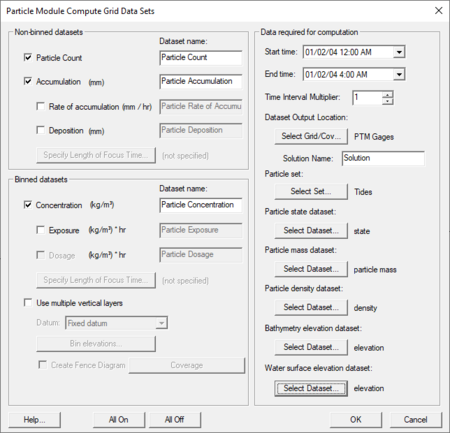
The Particle Module Compute Grid Datasets dialog is accessed through the particle module Data menu. This dialog is also used to compute datasets on fence diagrams (defined in a coverage).
The datasets are added to the active cartesian grid. It should be noted that the resolution of the grid will have an impact on the numerical values computed for several of these datasets. For example, the accumulation in a cell is computed as the volume of particles which have settled in a cell divided by the cell area. If the cells are larger, this will result in a smaller accumulation. A user may want to experiment with a few different grid resolutions.
Currently the following grid datasets can be created in the Particle Module Compute Grid Datasets dialog:
- Particle Count
The number of particles in the Cartesian grid cell.
- Accumulation
The depth of particles in the Cartesian grid cell. The volume of particles is calculated using the particle mass and density dataset for particles which are inactive (based on the state dataset) and in the cell. The volume in each cell is divided by the area of the cell to calculate an average depth in the cell. No voids ratio is included at this time, however the Data Calculator can be used to change the resulting Cartesian grid dataset.
- Rate of accumulation
The change in accumulation (as described above) over time.
- Deposition
- The change in depth of particles in the cartesian grid cell during the focus time. The volume of particles is calculated using the particle mass and density dataset for particles which have become inactive (based on the state dataset) during the focus time. This volume is then divided by the area of the cell to calculate an average depth in the cell. No voids ratio is included at this time, however the Data Calculator can be used to change the resulting cartesian grid dataset.
The concentration of particles in the Cartesian grid cell. The volume of particles is calculated using the particle mass and density dataset for particles which are active (based on the state dataset) and in the cell. This volume is then divided by the volume of the cell using the bathymetry and water surface elevation datasets. For this purpose, the bathymetry must be specified as an elevation dataset. This means that the values must be specified as positive upwards from the same datum the water surface dataset is measured from. For models such as CMS-Flow and ADCIRC, which require that the user specify positive depths (values measured down from mean sea level), the geometry (Z) dataset must be inverted to use for this application. The depth of the water column in a cell of the resulting grid is computed as WSE – Elevation. This depth is combined with the cell area to compute a cell volume. SMS is capable of extracting ground elevations (bathymetry) and water surface elevations from either a finite element mesh, or a scattered dataset. If the data is only available on a Cartesian grid (i.e. a CMS-Flow simulation), the user must convert this to a scatter set. Right-clicking on the grid and selecting the Convert | 2D Grid → 2D Scatter, will accomplish this. The datasets on the grid will be converted to the scattered data as well.
- Exposure
The cumulative concentration relative to time in the Cartesian grid cell.
- Dosage
The exposure in the Cartesian grid cell during the focus time.
Related Topics
| [hide] SMS – Surface-water Modeling System | ||
|---|---|---|
| Modules: | 1D Grid • Cartesian Grid • Curvilinear Grid • GIS • Map • Mesh • Particle • Quadtree • Raster • Scatter • UGrid |  |
| General Models: | 3D Structure • FVCOM • Generic • PTM | |
| Coastal Models: | ADCIRC • BOUSS-2D • CGWAVE • CMS-Flow • CMS-Wave • GenCade • STWAVE • WAM | |
| Riverine/Estuarine Models: | AdH • HEC-RAS • HYDRO AS-2D • RMA2 • RMA4 • SRH-2D • TUFLOW • TUFLOW FV | |
| Aquaveo • SMS Tutorials • SMS Workflows | ||
