Search results
From XMS Wiki
Jump to navigationJump to search
- Various menu commands are available when right-clicking on UGrid items in the Project Explorer. ==Project Explorer==3 KB (465 words) - 19:42, 28 March 2022
- ...includes all of the specific workflows needed in creating a general MODAEM project Newer and infrequent GMS users should start here. {{GMS Project Setup Workflow}}3 KB (320 words) - 18:40, 26 October 2016
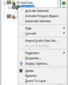
File:WMS GridProjectExplorer3.png [[Category:Project Explorer images]] Right-clicking on the dataset for a grid allows users to Export, Rename, view Properties, View Values, set Contour Options, and Set as Elevations.(264 × 330 (11 KB)) - 17:14, 9 March 2018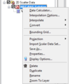
File:WMS ScatterProjectExplorer3.png [[Category:Project Explorer images]] ...ataset allows users to allows to create a New folder, Delete, Rename, view Properties, and Convert Coordinate Systems of the scattered dataset.(280 × 340 (10 KB)) - 14:33, 12 March 2018- ...terial_set_in_project_explorer.png|frame|right|125px|A material set in the Project Explorer.]] ...under a Material Sets [[File:Material Set Folder.svg|16 px]] folder in the Project Explorer. Although grid cells and mesh elements (as well as other objects)3 KB (415 words) - 21:15, 16 March 2022
- !style="text-align:left;"|1. Start with a completed MODFLOW Project. :# Open a completed MODFLOW project created using either the [[GMS:MODFLOW Grid Workflow|grid approach]] or [[G2 KB (250 words) - 18:41, 26 October 2016
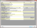
File:WMS HY12 Properties.png HY-12 Project Properties dialog.(840 × 638 (47 KB)) - 17:30, 4 December 2015- ...tains a hierarchical representation of the data associated with a modeling project. ...ies Window'']] – provides both information and opportunities to edit properties of WMS entities.2 KB (282 words) - 21:06, 28 January 2020
- ...oject_Explorer#Common_Project_Explorer_Data_Object_Right-Click_Commands|'''Properties''']]. :# Enter layer range values in the [[GMS:Solid Properties|''Properties'']] dialog.949 bytes (116 words) - 16:09, 23 February 2017
- ...the change affected the model. The original model is left unchanged. Each project can have multiple scenarios attached to it. ...e to be used for future scenarios—it is recommended you create a new project with correct inputs.5 KB (877 words) - 15:36, 5 September 2019
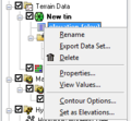
File:TerrainProjectExplorer4.png [[Category:Project Explorer images]] ...king on a dataset of a TIN allows the user to Delete, Export, Rename, view Properties, View values, set the dataset as elevations, or set the dataset contour opt(228 × 210 (9 KB)) - 16:30, 8 March 2018- ...drographs. The coverage type is set by right-clicking on a coverage in the Project Explorer and selecting ''Coverage Type''→'''HydroGeoSphere''', and then s ...ages that are not applied to a HydroGeoSphere simulation will not have the properties in the coverage included in the simulation run.2 KB (357 words) - 20:31, 3 May 2024
- ...ific workflows users will need to use in creating an [[SMS:FESWMS|FESWMS]] project. Newer and infrequent SMS users should start here. !style="text-align:left;"|1. Start a new SMS project.3 KB (404 words) - 17:25, 26 November 2018
- ...D drawing is controlled using the checkboxes in the [[GMS:Project Explorer|Project Explorer]]. Individual layers can be turned off/on. To turn off the display ...-click menu on the "[[File:Convert to CAD Icon.svg|16px]] CAD" item in the Project Explorer contains the following commands in addition to the standard object4 KB (642 words) - 14:24, 13 June 2022
- ...specific workflows users will need to use in creating an [[SMS:RMA2|RMA2]] project. Newer and infrequent SMS users should start here. !style="text-align:left;"|1. Start a new SMS project.3 KB (420 words) - 19:01, 28 June 2016
- ...ated that in future versions the CAD data will also be controlled from the Project Explorer. ...Project Explorer by selecting it. The active coverage is indicated in the Project Explorer display with a color map module icon, while the inactive coverages4 KB (520 words) - 23:45, 17 December 2019
- ...ght-Click_Commands|'''New Conceptual Model''']] right-click command in the Project Explorer. :# Use the [[GMS:Conceptual Model|''Conceptual Model Properties'']] dialog to create a new conceptual model.<noinclude>[[Category:GMS Workf325 bytes (41 words) - 22:40, 25 October 2016
- ...theme [[File:Display Theme Icon.svg|16 px]] data object will appear in the Project Explorer. This data object stores all of the [[SMS:Display Options|display ...a variety of options: views (general display, lighting, etc), visibility (Project Explorer settings), and geometry (display options for 2D mesh, map coverage5 KB (831 words) - 18:04, 15 August 2022
- ...ssingDataIcon.png]]) in the Project Explorer window and selecting '''Input Properties'''. The following culvert data are required: ...each culvert are also entered in the culvert data portion of the ''Culvert Properties'' window. There is the option of entering culvert invert data or embankmen824 bytes (113 words) - 20:35, 2 August 2022
- ...''Properties'' window provides both information and opportunities to edit properties of WMS entities. ==Properties Window Overview==4 KB (534 words) - 17:14, 17 January 2024


