SMS:1D Hyd Centerline Coverage: Difference between revisions
No edit summary |
No edit summary |
||
| (13 intermediate revisions by the same user not shown) | |||
| Line 4: | Line 4: | ||
The river reach properties include: | The river reach properties include: | ||
* ''Arc Type'' – | * ''Arc Type'' – Sets if the attributes are for a centerline, left bank, or right bank arc. <!--Custom arc type can be added.--> | ||
**'''Edit arc types''' – Opens the ''Arc Properties Types'' dialog where additional property types can be added. | |||
* ''River Name'' – only editable for a centerline arc. | * ''River Name'' – only editable for a centerline arc. | ||
* ''Reach Id'' – internally assigned and not editable. | * ''Reach Id'' – internally assigned and not editable. | ||
* ''Reach Name'' | * ''Reach Name'' | ||
* '' | * ''Use/Model Length'' – enerally equal to the length but this could be different in order to account for additional sinuosity. | ||
** '''Reset''' – will clear whatever has been entered for the '' | ** '''Reset''' – will clear whatever has been entered for the ''Use/Model Length''. | ||
* '' | * ''Computed'' – Computed length of the arc. | ||
* ''Start Station'' | * ''Start Station'' | ||
* ''End Station'' | * ''End Station'' | ||
<gallery widths="300 px" heights="380 px"> | |||
Image:1D-CenterlineExample.png|Centerline example | |||
File:SMS RiverReachAtt.png|The ''River Reach Attribute'' dialog | |||
</gallery> | |||
==Related Topics== | ==Related Topics== | ||
| Line 30: | Line 30: | ||
[[Category:SMS Coverages|1D Hyd]] | [[Category:SMS Coverages|1D Hyd]] | ||
[[Category:Hydraulic Modeling|1D Hyd]] | [[Category:Hydraulic Modeling|1D Hyd]] | ||
[[Category:Gallery]] | |||
Latest revision as of 22:48, 15 August 2022
The 1D-Hydraulic Centerline coverage has three possible attribute types: general, centerline, and bank. If the arc is a general arc type then it does not participate in the building of a hydraulic centerline and only provides additional visual detail to the model. A bank arc is used to mark left and right bank points for any cross sections that are automatically extracted from at digital terrain model.
A centerline arc provides the backbone of the hydraulic model definition. It's direction should be from upstream to downstream as this is the way HEC-RAS commonly views the river. This automatically defines which is the left bank and which is the right bank (think of standing up river and looking downstream when determining left and right). A centerline has as attributes the river reach properties as defined in the River Reach Attributes dialog.
The river reach properties include:
- Arc Type – Sets if the attributes are for a centerline, left bank, or right bank arc.
- Edit arc types – Opens the Arc Properties Types dialog where additional property types can be added.
- River Name – only editable for a centerline arc.
- Reach Id – internally assigned and not editable.
- Reach Name
- Use/Model Length – enerally equal to the length but this could be different in order to account for additional sinuosity.
- Reset – will clear whatever has been entered for the Use/Model Length.
- Computed – Computed length of the arc.
- Start Station
- End Station
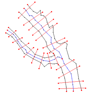
Centerline example
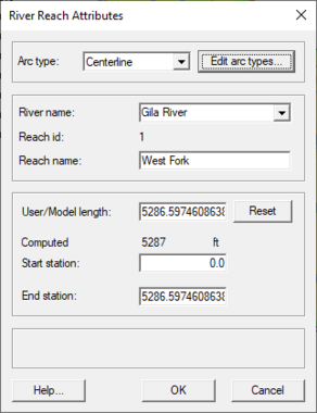
The River Reach Attribute dialog


Related Topics
SMS – Surface-water Modeling System | ||
|---|---|---|
| Modules: | 1D Grid • Cartesian Grid • Curvilinear Grid • GIS • Map • Mesh • Particle • Quadtree • Raster • Scatter • UGrid |  |
| General Models: | 3D Structure • FVCOM • Generic • PTM | |
| Coastal Models: | ADCIRC • BOUSS-2D • CGWAVE • CMS-Flow • CMS-Wave • GenCade • STWAVE • WAM | |
| Riverine/Estuarine Models: | AdH • HEC-RAS • HYDRO AS-2D • RMA2 • RMA4 • SRH-2D • TUFLOW • TUFLOW FV | |
| Aquaveo • SMS Tutorials • SMS Workflows | ||