SMS:1D River Conceptual Model: Difference between revisions
From XMS Wiki
Jump to navigationJump to search
m (e) |
No edit summary |
||
| (16 intermediate revisions by the same user not shown) | |||
| Line 1: | Line 1: | ||
SMS uses a conceptual model (coverages of | __NOINDEX__ | ||
{{SMS Deprecated Feature}} [[Category:Archived]] | |||
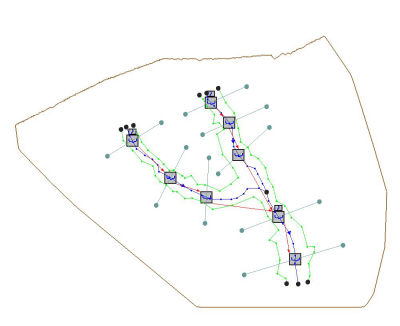
SMS uses a conceptual model (coverages of centerlines, and cross-sections) to define the hydraulic model, but at some point this conceptual model must be mapped to an equivalent topologic model representation for a Hydraulic model. [[SMS:HEC-RAS 11.2 and earlier|HEC-RAS]], for example, is defined as reaches and cross sections. Each reach and section has appropriate stationing defined from the spatial nature of the conceptual model. When choosing this command a schematic of the river is made for the appropriate model. The example below shows the reach (small boxes at the beginning of each reach) and section icons of the schematic for an HEC-RAS model. In the Hydraulic Modeling module the schematic is generally used as the view of the model. | |||
[[Image:River_Conceptual Model.jpg]] | [[Image:River_Conceptual Model.jpg]] | ||
| Line 5: | Line 8: | ||
== Related Topics == | == Related Topics == | ||
*[[SMS:1D | *[[SMS:1D Hyd Cross Section Coverage|1D Hyd Cross Section Coverage]] | ||
* [[SMS:1D River Module|1D River Module]] | * [[SMS:1D River Module|1D River Module]] | ||
{{Template: | |||
{{Template:Navbox SMS}} | |||
[[Category:SMS Map|1]] | |||
[[Category:SMS 1D River|1]] | |||
[[Category:Conceptual Model|1]] | |||
[[Category:Cross Sections]] | |||
Latest revision as of 14:05, 12 June 2019
| This contains information about features no longer in use for the current release of SMS. The content may not apply to current versions. |
SMS uses a conceptual model (coverages of centerlines, and cross-sections) to define the hydraulic model, but at some point this conceptual model must be mapped to an equivalent topologic model representation for a Hydraulic model. HEC-RAS, for example, is defined as reaches and cross sections. Each reach and section has appropriate stationing defined from the spatial nature of the conceptual model. When choosing this command a schematic of the river is made for the appropriate model. The example below shows the reach (small boxes at the beginning of each reach) and section icons of the schematic for an HEC-RAS model. In the Hydraulic Modeling module the schematic is generally used as the view of the model.
Related Topics
SMS – Surface-water Modeling System | ||
|---|---|---|
| Modules: | 1D Grid • Cartesian Grid • Curvilinear Grid • GIS • Map • Mesh • Particle • Quadtree • Raster • Scatter • UGrid |  |
| General Models: | 3D Structure • FVCOM • Generic • PTM | |
| Coastal Models: | ADCIRC • BOUSS-2D • CGWAVE • CMS-Flow • CMS-Wave • GenCade • STWAVE • WAM | |
| Riverine/Estuarine Models: | AdH • HEC-RAS • HYDRO AS-2D • RMA2 • RMA4 • SRH-2D • TUFLOW • TUFLOW FV | |
| Aquaveo • SMS Tutorials • SMS Workflows | ||
