Search results
From XMS Wiki
Jump to navigationJump to search
- ...lweg, left bank, right bank) can be defined from a 1D-Hydraulic Centerline coverage, or by AutoMark. The ''AutoMark'' option will examine the elevations of the Line properties can be determined from an area property coverage by intersecting the cross section arcs with the area property polygons and2 KB (292 words) - 16:57, 13 June 2018
- ...neral arc type then it does not participate in the building of a hydraulic centerline and only provides additional visual detail to the model. A bank arc is used ...anding up river and looking downstream when determining left and right). A centerline has as attributes the river reach properties as defined in the ''River Reac2 KB (271 words) - 18:47, 4 January 2024
- ...Centerline Coverage Type|1D-Hydraulic Centerline coverage]] including the centerline and bank arcs. #Create the [[WMS:1D-HYD Cross Section Coverage Type|cross section arcs]] at important/required locations along the section of r4 KB (684 words) - 16:56, 13 June 2018
- An Area Property coverage is very similar to a land use coverage or a soil coverage (and often are defined by converting one of these coverages to an area prop Each polygon in the area property coverage is assigned a material ID. Material IDs are then mapped as line properties2 KB (305 words) - 16:55, 13 June 2018
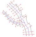
- ...ials (Manning's roughness coefficients) to the cross section based on some type of aerial distinction (land use or soils) that may be available. The diagra ...ram of a 1D-Hydraulic Centerline coverage and a 1D-Hydraulic Cross Section coverage.]]5 KB (810 words) - 22:55, 4 May 2020
- ...item and selecting '''New Coverage''' command followed by using the ''New Coverage'' dialog.. These coverages can be used with most models and simulations. ...terline Coverage|1D Hyd Centerline Coverage]] – Used to identify the centerline in the hydraulic model.3 KB (424 words) - 20:04, 15 August 2022
- #Cross sections can be interpolated along the centerline. #A centerline coverage can be created from annotated cross sections.6 KB (1,016 words) - 18:16, 4 May 2022
- #Cross sections can be interpolated along the centerline. #A centerline coverage can be created from annotated cross sections.7 KB (1,044 words) - 15:25, 1 March 2021
File:1D-CenterlineExample.png ...neral arc type then it does not participate in the building of a hydraulic centerline and only provides additional visual detail to the model. A bank arc is used(334 × 349 (6 KB)) - 14:43, 18 September 2017- ...objects could not be included in a single coverage since polygons within a coverage are not allowed to overlap. ...The visibility of a coverage is controlled using the check box next to the coverage in the Project Explorer.5 KB (704 words) - 19:44, 8 May 2023
- ...1. Create a [[SMS:TUFLOW_Coverages#1D_Network_Coverage|TUFLOW 1D Network]] coverage. : Create a new coverage with the TUFLOW "1D Network" type.1 KB (154 words) - 14:42, 27 June 2017
- For the new 1D Hydraulic Cross Section coverage, the cross section geometry is stored in a text database file on disk. When ...in a [[WMS:1D-HYD Cross Section Coverage Type|1D Hydraulic Cross Section]] coverage. After assigning the cross section, it also possible to enter the editor fo5 KB (849 words) - 22:48, 4 May 2020
- ...ent land use (roughness) types found in the floodplain. After building the coverage, define each polygon attribute by double-clicking on the polygon and assign * [[WMS:1D-HYD Centerline Coverage Type|1D-Hydraulic Centerline Coverage]]2 KB (266 words) - 20:30, 8 June 2023
- ...igital terrain model in order to determine the thalweg position (from the centerline arc) and the left and right bank points (from the bank arcs). ==Coverage Specific Right-Click Commands==17 KB (2,668 words) - 22:31, 15 August 2022
- For the 1D Hydraulic Cross Section coverage and the TUFLOW 1D Cross Section coverage, the cross section geometry is stored in text database file on disk. When # When double-clicking on an arc in a 1D Hydraulic Cross Section coverage, it's possible to assign a cross section from a database. After assigning5 KB (846 words) - 20:48, 18 April 2022
- The GenCade map module coverage can be converted to a 1D grid. * [[SMS:Converting_Feature_Objects#Map_to_2D_Grid|Area Property map coverage]]7 KB (1,176 words) - 14:18, 25 July 2017
- :[[WMS:Coverage Overlays|Coverage Overlays]] :[[WMS:1D-HYD Centerline Coverage Type|1D-HYD Centerline]]8 KB (1,104 words) - 22:12, 18 December 2019
- User defined cross sections are defined from a cross-section coverage and can be interpolated from a background TIN or DEM. ...ge exists the new scatter point will be created at the intersection of the centerline and cross section when selecting the '''Create Stage Point''' button. A se4 KB (587 words) - 21:57, 4 May 2020
- ...urned on, SMS will create a new database or add to the existing one if the coverage already uses one. Point properties for the cross-section database (such as ...lected, but the user the can click on the coverage button and change which coverage to place the imported data.9 KB (1,402 words) - 15:43, 23 December 2020
- *1D Hyd Centerline coverage with a defined centerline arc. *1D Hyd Cross Sections coverage with defined cross section arcs.7 KB (975 words) - 18:55, 20 August 2020
