Nodata to Polygon Tool
From XMS Wiki
This is the approved revision of this page, as well as being the most recent.
Nodata to Polygon
The Nodata to Polygon tool creates a new coverage with polygons bounding all of the active regions of the raster including inactive regions that fall within an interior polygon.
Inactive regions of a raster are determined by the NODATA value of the raster.
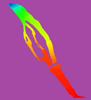
Raster containing NODATA cells (shown in purple) shown surrounding a river with dry islands 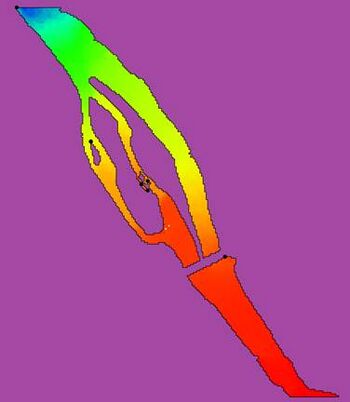
Polygons surrounding the active region of the raster, including interior islands


Input Parameters
- Input raster – The raster for which the active boundary polygon will be created.
- Number of cells required to make a polygon – The number of cells required to make a polygon. Any interior areas that contain less raster cells than this number will not be enveloped with a polygon.
Output Parameters
- Output coverage – The new coverage to be created, containing the boundary polygon for the active region of the input raster.
Current Location in Toolbox
Rasters/Nodata to Polygon
| [hide] SMS – Surface-water Modeling System | ||
|---|---|---|
| Modules: | 1D Grid • Cartesian Grid • Curvilinear Grid • GIS • Map • Mesh • Particle • Quadtree • Raster • Scatter • UGrid |  |
| General Models: | 3D Structure • FVCOM • Generic • PTM | |
| Coastal Models: | ADCIRC • BOUSS-2D • CGWAVE • CMS-Flow • CMS-Wave • GenCade • STWAVE • WAM | |
| Riverine/Estuarine Models: | AdH • HEC-RAS • HYDRO AS-2D • RMA2 • RMA4 • SRH-2D • TUFLOW • TUFLOW FV | |
| Aquaveo • SMS Tutorials • SMS Workflows | ||