User:Rcorrigan/AHGW Pro:Reverse Section Line Orientation: Difference between revisions
No edit summary |
No edit summary |
||
| (One intermediate revision by the same user not shown) | |||
| Line 9: | Line 9: | ||
The following fields are available. Required fields are marked with a [[File:ArcGIS Pro Red Required Symbol.png|8 px]] icon. In ArcGIS, they are marked with a [[File:ArcGIS required - green circle icon.png|8px]] icon. Fields marked with a [[File:ArcGIS Pro Warning Red.png|12 px]] icon may not be supported or the table may not exist. | The following fields are available. Required fields are marked with a [[File:ArcGIS Pro Red Required Symbol.png|8 px]] icon. In ArcGIS, they are marked with a [[File:ArcGIS required - green circle icon.png|8px]] icon. Fields marked with a [[File:ArcGIS Pro Warning Red.png|12 px]] icon may not be supported or the table may not exist. | ||
*[[File:ArcGIS Pro Red Required Symbol.png|8 px]] ''Input SectionLine Features'' – Click the [[File:ArcGISPro Open.png|16 px]] button to bring up the ''Input SectionLine Features'' dialog in order to specify the layer or feature class containing the SectionLine(s) to flip. The tool works on a selected set of SectionLine features. If no features are selected the tool will run on all SectionLine features. | *[[File:ArcGIS Pro Red Required Symbol.png|8 px]] ''Input SectionLine Features'' – Click the [[File:ArcGISPro Open.png|16 px]] button to bring up the ''Input SectionLine Features'' dialog in order to specify the layer or feature class containing the SectionLine(s) to flip. The tool works on a selected set of SectionLine features. If no features are selected the tool will run on all SectionLine features. | ||
*''HydroID of Section Line to Flip'' – Optional. Enter the HydroID of a single SectionLine that is to be flipped. | *''HydroID of Section Line to Flip'' – Optional. Enter the HydroID of a single SectionLine that is to be flipped. Alternatively, you can select the desired line(s) to flip in a map view with the Select tool. | ||
:*'''''ArcGIS Feature Note''''' – | :*'''''ArcGIS Feature Note''''' – For ArcGIS, you can select the desired line(s) to flip in [[ArcMap]] with the Select Features tool. | ||
{{Navbox AHGW}} | {{Navbox AHGW}} | ||
[[Category:AHGW Subsurface Analyst]] | [[Category:AHGW Subsurface Analyst]] | ||
Latest revision as of 20:37, 22 August 2022
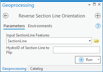
The Reverse Section Line Orientation tool is accessed by double-clicking on "![]() Reverse Section Line Orientation" under the "
Reverse Section Line Orientation" under the "![]() XS2D Editor" toolset under the "
XS2D Editor" toolset under the "![]() Subsurface Analyst" toolset under the "
Subsurface Analyst" toolset under the "![]() ArcHydroGroundwater.pyt" toolbox. This tool reverses the parameterization of the curve ('from' point becomes 'to' point, first segment becomes last segment, etc).
ArcHydroGroundwater.pyt" toolbox. This tool reverses the parameterization of the curve ('from' point becomes 'to' point, first segment becomes last segment, etc).
This is useful for 'flipping' SectionLine that will be used to create cross sections. Cross sections typically start a X = 0 at the beginning of the SectionLine, and are drawn to the right with increasing distance along the SectionLine. If the 'from' point is on the opposite end of the SectionLine from the one the user intended, this tool can be used to reverse the orientation of the line so that the 'from' point is where the user intended the beginning of the line to be. While this tool was intended for use with SectionLines, it can be used on any polyline feature class.
- ArcGIS Notes – In older versions of ArcGIS, this tool is accessed through the "Arc Hydro Groundwater Tools" toolbox. The tool appears as a dialog, not a pane.
- The icons vary between ArcGIS and ArcGIS Pro.
- The names of the fields in this tool might be different in ArcGIS. They should still be recognizable.
The following fields are available. Required fields are marked with a ![]() icon. In ArcGIS, they are marked with a
icon. In ArcGIS, they are marked with a ![]() icon. Fields marked with a
icon. Fields marked with a ![]() icon may not be supported or the table may not exist.
icon may not be supported or the table may not exist.
 Input SectionLine Features – Click the
  button to bring up the Input SectionLine Features dialog in order to specify the layer or feature class containing the SectionLine(s) to flip. The tool works on a selected set of SectionLine features. If no features are selected the tool will run on all SectionLine features.
- HydroID of Section Line to Flip – Optional. Enter the HydroID of a single SectionLine that is to be flipped. Alternatively, you can select the desired line(s) to flip in a map view with the Select tool.
- ArcGIS Feature Note – For ArcGIS, you can select the desired line(s) to flip in ArcMap with the Select Features tool.

