SMS:Functional Surfaces: Difference between revisions
From XMS Wiki
Jump to navigationJump to search
No edit summary |
No edit summary |
||
| Line 3: | Line 3: | ||
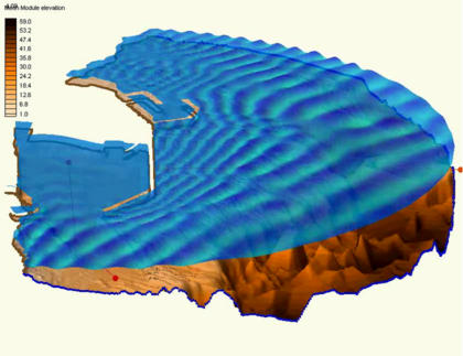
A functional surface is exactly that. It is a surface representing one of the functional datasets associated with a mesh, grid or TIN. The most intuitive example of a functional surface is the display of the water surface over a model's bathymetry. In this case, the surface represents an actual physical surface, but the functional surface could just as easily represent the velocity magnitude, or concentration, or any other scalar quantity. | A functional surface is exactly that. It is a surface representing one of the functional datasets associated with a mesh, grid or TIN. The most intuitive example of a functional surface is the display of the water surface over a model's bathymetry. In this case, the surface represents an actual physical surface, but the functional surface could just as easily represent the velocity magnitude, or concentration, or any other scalar quantity. | ||
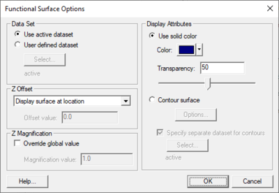
[[Image:SMS Functional Surface Opt. | [[Image:SMS Functional Surface Opt.png|thumb|400 px|''Functional Surfaces Options'' dialog]] | ||
To create/display functional surfaces, enable them in the display options of the appropriate module, and specify their attributes which include: | To create/display functional surfaces, enable them in the display options of the appropriate module, and specify their attributes which include: | ||
Revision as of 23:06, 23 June 2020
At a glance
- Surface with elevation based upon scalar dataset values
- Very useful for wave models and models with large change in water surface elevation
- Elevations can be exaggerated to better visualize dataset variations
- Surfaces can have a solid color or use color filled contours
- Transparency can be used to allow see through surfaces
A functional surface is exactly that. It is a surface representing one of the functional datasets associated with a mesh, grid or TIN. The most intuitive example of a functional surface is the display of the water surface over a model's bathymetry. In this case, the surface represents an actual physical surface, but the functional surface could just as easily represent the velocity magnitude, or concentration, or any other scalar quantity.
To create/display functional surfaces, enable them in the display options of the appropriate module, and specify their attributes which include:
- Dataset – Selects which dataset is to be used to form the functional surface.
- Use active dataset
- User defined dataset
- Z Offset – SMS displays functional surfaces at a simulated z-value. This may be the actual surface value (such as is the case with water surfaces elevations), but more often the value will not have a physical meaning, and may intersect the bathymetry or not even be in the same area. For this reason, SMS offers options for placing the functional surface at its real values, relative to the bathymetry, or at a user specified offset.
- Z Magnification – Functional data may not vary significantly when compared to the horizontal extents of the model. For this reason, the interface allows magnification (scaling) of the functional surface. By default, the surface is scaled based on the global z-magnification specified in the general display options. This may be overridden.
- Override global value
- Magnification value
- Display Attributes – Controls the color of the functional surface. It may be a constant color or colored based on the contour colors specified. The colors may be associated with the value of the functional surface, or another dataset. The surface may also be partially transparent.
- Use solid color
- Transparency
- Contour surface
- Specify separate dataset for contours
Related Topics
SMS – Surface-water Modeling System | ||
|---|---|---|
| Modules: | 1D Grid • Cartesian Grid • Curvilinear Grid • GIS • Map • Mesh • Particle • Quadtree • Raster • Scatter • UGrid |  |
| General Models: | 3D Structure • FVCOM • Generic • PTM | |
| Coastal Models: | ADCIRC • BOUSS-2D • CGWAVE • CMS-Flow • CMS-Wave • GenCade • STWAVE • WAM | |
| Riverine/Estuarine Models: | AdH • HEC-RAS • HYDRO AS-2D • RMA2 • RMA4 • SRH-2D • TUFLOW • TUFLOW FV | |
| Aquaveo • SMS Tutorials • SMS Workflows | ||

