AHGW:Import GeoSection from XML
From XMS Wiki
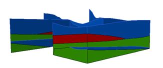
The tool imports 3D GeoSection features (3D multipatches) from an XML file in Arc Hydro Groundwater (AHGW). The XML file is structured as a set of SectionLines and GeoSections. The geometry of the SectionLine and GeoSection objects is defined by a set of vertices, where each vertex is defined by X, Y, and Z coordinates.
The GeoSection features created can be viewed in ArcScene.

Following the AHGW data model design, a set of optional attributes are included to describe the features.
SectionLine:
- HydroID – Unique feature identifier within the geodatabase.
- HydroCode – Permanent public identifier.
- SName – Section name (e.g. A-A’).
- FType – Type of the GeoSection.
GeoSection:
- HydroID – Unique feature identifier within the geodatabase.
- HydroCode – Permanent public identifier.
- SectionID – HydroID of the related SectionLine.
- SName – The section name (e.g. A-A’).
- HGUID – Hydrogeologic unit identifier.
- HGUCode – Hydrogeologic unit code.
- FromWell – The HydroID of a related well (applicable to borehole derived cross sections)
- ToWell – The HydroID of a related well feature (applicable to borehole derived cross sections)
- FType – The type of the GeoSection.
| [show] AHGW – Arc Hydro Groundwater Toolbox |
|---|
