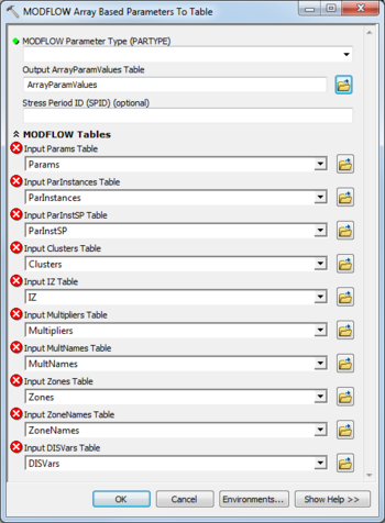
AHGW:MODFLOW Array Based Parameters to Table
From XMS Wiki
Jump to navigationJump to search
The MODFLOW Array Based Parameters to Table tool is accessed by double-clicking on "![]() MODFLOW Array Based Parameters to Table" under the "
MODFLOW Array Based Parameters to Table" under the "![]() Tables" toolset under the "
Tables" toolset under the "![]() MODFLOW Analyst" toolset under the "
MODFLOW Analyst" toolset under the "![]() Arc Hydro Groundwater Tools" toolbox. This tool creates a table with data corresponding to MODFLOW array based parameters.
Arc Hydro Groundwater Tools" toolbox. This tool creates a table with data corresponding to MODFLOW array based parameters.
The following fields are available. Required fields are marked with a ![]() icon. Fields marked with a
icon. Fields marked with a ![]() icon may either not be supported or the table doesn't exist.
icon may either not be supported or the table doesn't exist.
 MODFLOW Parameter Type (PARTYPE) – The MODFLOW parameter type to calculate. Select one from the following choices:
- "HK" – Defines variable HK, horizontal hydraulic conductivity.
- "HANI" – Defines variable HANI, horizontal anisotropy.
- "VK" – Defines variable VK, vertical hydraulic conductivity.
- "VANI" – Defines variable VANI, vertical anisotropy.
- "SS" – Defines variable Ss, the specific storage.
- "SY" – Defines variable Sy, the specific yield .
- "VXCB" – Defines variable VKCB, the vertical hydraulic conductivity of a Quasi-three-dimensional confining layer.
- "SYTP" – When all model layers are confined, defines the storage coefficient for the top active cell at each row, column location.
- "RCH" – Defines values of the recharge flux.
- "EVT" – Defines values of the maximum ET flux.
- "ETS" – Defines values of the maximum ET flux.
- Output ArrayParamValues Table – Click the
 button to bring up the Output ArrayParamValues Table dialog in order to specify the ArrayParamValues table, in MODFLOW Data Model format. This table stores the array based parameter values by IJ or IJK value, and stress period ID (if applicable).
 - Stress Period ID – Optional. Specify a specific stress period ID to calculate.
- MODFLOW Tables
- Input Params Table – Click the
 button to bring up the Input Params Table dialog in order to specify the Params table, in MODFLOW Data Model format.
 - Input ParInstances Table – Click the
 button to bring up the Input ParInstances Table dialog in order to specify the ParInstances table, in MODFLOW Data Model format.
 - Input ParInstSP Table – Click the
 button to bring up the Input ParInstSP Table dialog in order to specify the ParInstSP table, in MODFLOW Data Model format.
 - Input Clusters Table – Click the
 button to bring up the Input Clusters Table dialog in order to specify the Clusters table, in MODFLOW Data Model format.
 - Input IZ Table – Click the
 button to bring up the Input IZ Table dialog in order to specify the IZ table, in MODFLOW Data Model format.
 - Input Multipliers Table – Click the
 button to bring up the Input Multipliers Table dialog in order to specify the Multipliers table, in MODFLOW Data Model format.
 - Input MultNames Table – Click the
 button to bring up the Input MultNames Table dialog in order to specify the MultNames table, in MODFLOW Data Model format.
 - Input Zones Table – Click the
 button to bring up the Input Zones Table dialog in order to specify the Zones table, in MODFLOW Data Model format.
 - Input ZoneNames Table – Click the
 button to bring up the Input ZoneNames Table dialog in order to specify the ZoneNames table, in MODFLOW Data Model format.
 - Input DISVars Table – Click the
 button to bring up the Input DISVars Table dialog in order to specify the DISVars table, in MODFLOW Data Model format.

