AHGW:Import GeoSection from XML
From XMS Wiki
Jump to navigationJump to search
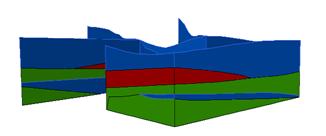
File:AHGW Import GeoSection From XML.jpg
XML file representing 3D cross sections.
The tool imports 3D GeoSection features (3D multipatches) from an XML file in Arc Hydro Groundwater (AHGW). The XML file is structured as a set of SectionLines and GeoSections. The geometry of the SectionLine and GeoSection objects is defined by a set of vertices, where each vertex is defined by X, Y, and Z coordinates.
The GeoSection features created can be viewed in ArcScene.
Following the AHGW data model design, a set of optional attributes are included to describe the features.
SectionLine:
- HydroID – Unique feature identifier within the geodatabase.
- HydroCode – Permanent public identifier.
- SName – Section name (e.g. A-A’).
- FType – Type of the GeoSection.
GeoSection:
- HydroID – Unique feature identifier within the geodatabase.
- HydroCode – Permanent public identifier.
- SectionID – HydroID of the related SectionLine.
- SName – The section name (e.g. A-A’).
- HGUID – Hydrogeologic unit identifier.
- HGUCode – Hydrogeologic unit code.
- FromWell – The HydroID of a related well (applicable to borehole derived cross sections)
- ToWell – The HydroID of a related well feature (applicable to borehole derived cross sections)
- FType – The type of the GeoSection.

