SMS:Mapping Coverage: Difference between revisions
From XMS Wiki
Jump to navigationJump to search
No edit summary |
|||
| Line 1: | Line 1: | ||
==Mapping Arc Attributes Dialog== | |||
[[Image:Mapping Arc Att.jpg|thumb|225 px|''Arc Attributes'' dialog]] | |||
==Mapping Polygon Attributes Dialog== | ==Mapping Polygon Attributes Dialog== | ||
[[Image:Mapping Polygon Attributes.jpg|thumb|225 px|''Polygon | [[Image:Mapping Polygon Attributes.jpg|thumb|225 px|''Polygon Attributes'' dialog]] | ||
The ''Polygon Attributes'' dialog is used to set the attributes for [[SMS:Feature Objects Types|feature polygons]] in a Mapping type coverage. Attributes that can be specified for each polygon include: | The ''Polygon Attributes'' dialog is used to set the attributes for [[SMS:Feature Objects Types|feature polygons]] in a Mapping type coverage. Attributes that can be specified for each polygon include: | ||
* Extrapolation Type | * Extrapolation Type | ||
Revision as of 21:19, 14 May 2013
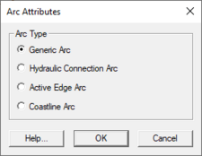
Mapping Arc Attributes Dialog
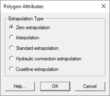
Mapping Polygon Attributes Dialog
The Polygon Attributes dialog is used to set the attributes for feature polygons in a Mapping type coverage. Attributes that can be specified for each polygon include:
- Extrapolation Type
- Zero extrapolation
- Interpolation
- Standard extrapolation
- Hydraulic connection extrapolation
- Coastline extrapolation
The dialog is reached by double-clicking on a polygon with the Select Feature Poygon tool with the Mapping type coverage active.
Related Topics
SMS – Surface-water Modeling System | ||
|---|---|---|
| Modules: | 1D Grid • Cartesian Grid • Curvilinear Grid • GIS • Map • Mesh • Particle • Quadtree • Raster • Scatter • UGrid |  |
| General Models: | 3D Structure • FVCOM • Generic • PTM | |
| Coastal Models: | ADCIRC • BOUSS-2D • CGWAVE • CMS-Flow • CMS-Wave • GenCade • STWAVE • WAM | |
| Riverine/Estuarine Models: | AdH • HEC-RAS • HYDRO AS-2D • RMA2 • RMA4 • SRH-2D • TUFLOW • TUFLOW FV | |
| Aquaveo • SMS Tutorials • SMS Workflows | ||

