User:Rcorrigan/AHGW Pro:Create XS2D Catalog Table: Difference between revisions
(Created page with "__NOINDEX__ 350px|thumb|right|''Create XS2D_Catalog Table'' dialog The ''Create XS2D_Catalog Table...") |
No edit summary |
||
| Line 1: | Line 1: | ||
__NOINDEX__ | __NOINDEX__ | ||
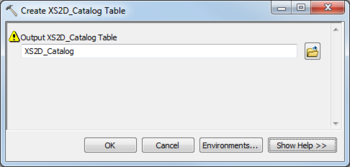
[[File:AHGW Subsurface Analyst XS2D Editor - Create XS2D_Catalog Table.png|350px|thumb|right|''Create XS2D_Catalog Table'' dialog]] | [[File:AHGW Subsurface Analyst XS2D Editor - Create XS2D_Catalog Table.png|350px|thumb|right|''Create XS2D_Catalog Table'' dialog]] | ||
The ''Create XS2D_Catalog Table'' tool is accessed by double-clicking on "[[File: | The ''Create XS2D_Catalog Table'' tool is accessed by double-clicking on "[[File:ArcGISPro Toolbx Tool.png|16 px]] Create XS2D_Catalog Table" under the "[[File:ArcGISPro Toolset.png|16 px]] XS2D Editor" toolset under the "[[File:ArcGISPro Toolset.png|16 px]] Subsurface Analyst" toolset under the "[[File:ArcGISPro Toolbx Item.png|16 px]] ArcHydroGroundwater.pyt" toolbox. This tool creates a system table used by the Arc Hydro Groundwater tools to manage 2D cross section features. Each row in the table stores information about a feature class participating in a 2D cross section, including information about the role that the feature class plays in the cross section and the section line defining the cross section. | ||
The following fields are available. Required fields are marked with a [[File:ArcGIS required - green circle icon.png|8px]] icon. Fields marked with a [[File:ArcGIS | The following fields are available. Required fields are marked with a [[File:ArcGIS Pro Red Required Symbol.png|8 px]] icon. In ArcGIS, they are marked with a [[File:ArcGIS required - green circle icon.png|8px]] icon. Fields marked with a [[File:ArcGIS Pro Warning Red.png|12 px]] icon may not be supported or the table may not exist. | ||
*''Output XS2D_Catalog Table'' – Click the [[File: | *[[File:ArcGIS Pro Red Required Symbol.png|8 px]] ''Output XS2D_Catalog Table'' – Click the [[File:ArcGISPro Open.png|16 px]] button to bring up the ''Input XS2D_Catalog Table'' dialog in order to specify the empty 2D cross section catalog table created by the tool. | ||
{{Navbox AHGW}} | {{Navbox AHGW}} | ||
[[Category:AHGW Subsurface Analyst]] | [[Category:AHGW Subsurface Analyst]] | ||
Revision as of 18:29, 22 August 2022
The Create XS2D_Catalog Table tool is accessed by double-clicking on "![]() Create XS2D_Catalog Table" under the "
Create XS2D_Catalog Table" under the "![]() XS2D Editor" toolset under the "
XS2D Editor" toolset under the "![]() Subsurface Analyst" toolset under the "
Subsurface Analyst" toolset under the "![]() ArcHydroGroundwater.pyt" toolbox. This tool creates a system table used by the Arc Hydro Groundwater tools to manage 2D cross section features. Each row in the table stores information about a feature class participating in a 2D cross section, including information about the role that the feature class plays in the cross section and the section line defining the cross section.
ArcHydroGroundwater.pyt" toolbox. This tool creates a system table used by the Arc Hydro Groundwater tools to manage 2D cross section features. Each row in the table stores information about a feature class participating in a 2D cross section, including information about the role that the feature class plays in the cross section and the section line defining the cross section.
The following fields are available. Required fields are marked with a ![]() icon. In ArcGIS, they are marked with a
icon. In ArcGIS, they are marked with a ![]() icon. Fields marked with a
icon. Fields marked with a ![]() icon may not be supported or the table may not exist.
icon may not be supported or the table may not exist.
 Output XS2D_Catalog Table – Click the
  button to bring up the Input XS2D_Catalog Table dialog in order to specify the empty 2D cross section catalog table created by the tool.

