GMS:Horizons to UGrid: Difference between revisions
From XMS Wiki
Jump to navigationJump to search
No edit summary |
|||
| Line 17: | Line 17: | ||
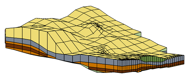
When the '''Horizon→UGrid''' command is executed the horizons specified on the borehole contacts or TIN nodes are converted to a set of scatter points with one dataset for each horizon. The scatter points are then used to interpolate a surface for each horizon. Starting with the lowest numbered horizon, the surface is extruded down to create a set of cells in a UGrid. The surface corresponding to the next horizon is then extruded down to fill in the space between that surface and the previous surface. This process is repeated for each surface. At each step, a set of cells are created for the current horizon and all previously defined cells are subtracted from that layer, resulting in an incremental buildup of the stratigraphy from the bottom to the top. The entire process results in a UGrid with each horizon layer represented by a material zone. | When the '''Horizon→UGrid''' command is executed the horizons specified on the borehole contacts or TIN nodes are converted to a set of scatter points with one dataset for each horizon. The scatter points are then used to interpolate a surface for each horizon. Starting with the lowest numbered horizon, the surface is extruded down to create a set of cells in a UGrid. The surface corresponding to the next horizon is then extruded down to fill in the space between that surface and the previous surface. This process is repeated for each surface. At each step, a set of cells are created for the current horizon and all previously defined cells are subtracted from that layer, resulting in an incremental buildup of the stratigraphy from the bottom to the top. The entire process results in a UGrid with each horizon layer represented by a material zone. | ||
[[Image:Hor_UGrid.png|none|frame|UGrid created via the horizons method]] | :[[Image:Hor_UGrid.png|none|frame|UGrid created via the horizons method]] | ||

