WMS:MWBM Wizard
The MWBM Wizard dialog is accessed through the MWBM Wizard ![]() tool icon in the WMS Graphics Window. Mine Water Balance Modeling (MWBM) can be used to update a GSSHA model within WMS by using this dialog.
tool icon in the WMS Graphics Window. Mine Water Balance Modeling (MWBM) can be used to update a GSSHA model within WMS by using this dialog.
On the left of the dialog is a list of pages that allow modification of various parameters and data to be used in updating and running the GSSHA model. The name of the dialog changes as each page is selected from the list on the left. The pages should generally be selected and completed in the order they appear in the list.
Each of these pages is discussed and explained below.
Read Existing Model
When this page is selected, the title of the dialog is Project Filename.
The "Read Existing Model" page has one item:
- Browse for WMS project filename – Click Browse
 to bring up the Select WMS Project File dialog. Browse to the location of the desired project file.
Define Model Changes
When this page is selected, the title of the dialog is Model Changes.
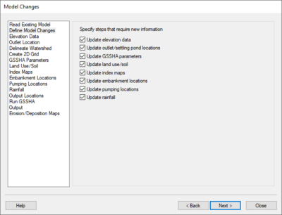
The "Define Model Changes" page allows the specification of pages in the dialog that require new information. These checkboxes allow the user to automatically skip particular pages when using the Next button if that information doesn't require updating. The user can still visit the other pages, if needed. Some options will cover more than one page.
Under Specify steps that require new information, the following options are available:
- Update elevation data &ndash - Takes the user to the "Elevation Data", "Outlet Location", "Delineate Watershed", "Create 2D Grid", and "Output Locations" pages before running GSSHA.
- Update outlet/settling pond locations &ndash - Takes user to "Outlet Locations", "Delineate Watershed", "Create 2D Grid", and "Output Locations" pages before running GSSHA.
- Update GSSHA parameters &ndash - Takes the user to the "GSSHA Parameters" and "Output Locations" pages before running GSSHA.
- Update land use/soil &ndash - Takes the user to the "Land Use/Soil" and "Output Locations" pages before running GSSHA.
- Update index maps &ndash - Takes the user to the "Index Maps" and "Output Locations" pages before running GSSHA.
- Update embankment locations &ndash - Takes the user to the "Embankment Locations" and "Output Locations" pages before running GSSHA.
- Update pumping locations &ndash - Takes the user to the "Pumping Locations" and "Output Locations" pages before running GSSHA.
- Update rainfall &ndash - Takes the user to the "Rainfall" and "Output Locations" pages before running GSSHA.
Elevation Data
When this page is selected, the title of the dialog is Elevation Data.
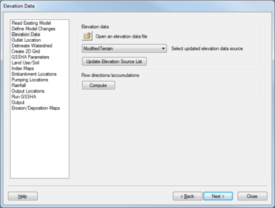
This page has two sections: Elevation data and Flow directions/accumulations.
Elevation data
There are three parts to this section:
- To use elevation data different than what is already in the opened project, click Browse
 to bring up the Select DEM File(s) dialog. This allows a new DEM to be imported into the project.
 - The Select updated elevation data source drop-down contains a listing of all the available elevation data sources. Select the desired DEM from the drop-down to update the 2D grid.
- Click the Update Elevation Source List button after importing a new DEM, then select it as the desired elevation data source from the drop-down above.
Flow direction/accumulations
Clicking the Compute button computes the flow directions and accumulations for the new terrain dataset (the DEM). If the imported file has these pre-computed, it is not necessary to click this button.
Outlet Location
When this page is selected, the title of the dialog is Outlet Location.
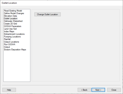
This page contains a single button: Change Outlet Location. These steps must be followed by delineating the watershed.
Follow these steps to select the new outlet location:
- Click Change Outlet Location to change the cursor to a small cross-hair icon.
- In the Main Graphics Window in WMS, click on the desired new location for the outlet. The outlet must be in an flow accumulation cell; an error message will popup advising the user if the selected location is not an accumulation cell.
- If needed, use the Property section of the Main Graphics Window to manually adjust the Feature Point X and Feature Point Y locations.
Delineate Watershed
When this page is selected, the title of the dialog is Delineate Watershed.
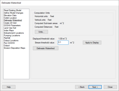
This page has a Computation Units section, followed by a single option and the Delineate Watershed button.
Computation Units
The Delineate Watershed step is used to delineate a watershed.
Compute flow directions/accumulations using TauDEM or TOPAZ – Select this button to compute flow directions and accumulations on the DEM while delineating the watershed. If the outlet is not in a flow accumulation cell, move the outlet, and run the delineate watershed command again. If there are flow directions and accumulations already computed, unselect this button before delineating the watersheds to save computation time. Options exists to use either TauDEM (Terrain Analysis Using Digital Elevation Models) or TOPAZ (Topographic Parameterization Program) to calculate flows.
Stream threshold value – This value is used to modify the stream density. Lower values will cause the streams to be more dense while higher values will create fewer streams in the completed model.
Apply to Display – Select this button to apply the stream threshold value entered to the display.
Create Tc Coverage – If this toggle is selected, a Time Computation coverage containing an arc with the longest flow path is created after delineating the watershed and sub-basins.
Units – This button is used to define the model and computation coordinates and units. Turn on the option to create a Tc coverage and change which data is computed by selecting the Drain Data Compute Opts... button in the Units dialog.
After delineating a watershed, it is possible to manually edit the extents of the watershed.
Create 2D Grid
When this page is selected, the title of the dialog is Create 2D Grid.
GSSHA Parameters
When this page is selected, the title of the dialog is GSSHA Parameters.
Land Use/Soil
When this page is selected, the title of the dialog is Define Land Use and Soil Data.
Index Maps
When this page is selected, the title of the dialog is Index Maps.
Embankment Locations
When this page is selected, the title of the dialog is Embankment Locations.
Pumping Locations
When this page is selected, the title of the dialog is Pumping Locations.
Rainfall
When this page is selected, the title of the dialog is Define Precipitation.
Output Locations
When this page is selected, the title of the dialog is Output Locations.
Run GSSHA
When this page is selected, the title of the dialog is Run Hydrologic Model.
Output
When this page is selected, the title of the dialog is Output.
Erosion/Deposition Maps
When this page is selected, the title of the dialog is Erosion/Deposition Maps.
WMS – Watershed Modeling System | ||
|---|---|---|
| Modules: | Terrain Data • Drainage • Map • Hydrologic Modeling • River • GIS • 2D Grid • 2D Scatter |  |
| Models: | CE-QUAL-W2 • GSSHA • HEC-1 • HEC-HMS • HEC-RAS • HSPF • MODRAT • NSS • OC Hydrograph • OC Rational • Rational • River Tools • Storm Drain • SMPDBK • SWMM • TR-20 • TR-55 | |
| Toolbars: | Modules • Macros • Units • Digitize • Static Tools • Dynamic Tools • Drawing • Get Data Tools | |
| Aquaveo | ||


