WMS:OC Rational Initial Sub-area Time of Concentration: Difference between revisions
From XMS Wiki
Jump to navigationJump to search
No edit summary |
No edit summary |
||
| Line 18: | Line 18: | ||
{{WMSMain}} | {{WMSMain}} | ||
[[Category:OC Rational|I]] | [[Category:OC Rational|I]] | ||
[[Category:OC Rational Dialogs]] | [[Category:OC Rational Dialogs|I]] | ||
[[Category:Equations]] | [[Category:Equations]] | ||
{{stub}} | {{stub}} | ||
Revision as of 15:34, 26 August 2016
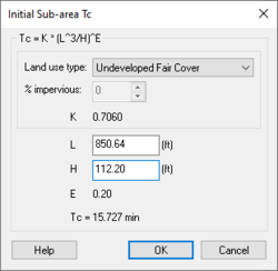
The time of concentration for initial sub-areas is a critical component in performing a Orange County Rational Method analysis. The time of concentration is defined as the interval of time (minutes) required for the flow at a given point to become a maximum under a uniform rainfall intensity. Generally, the time of concentration is the interval of time from the beginning of rainfall for water from the hydraulically most remote portion of the drainage area to reach the point of concentration. For a Orange County analysis, the time of concentration is calculated using the following equation:
where:
- – Coefficient depending on percent impervious (land use type)
- – Length of initial sub area flow path (ft)
- – Drop in elevation along the flow path (ft)
- – Orange County constant = 0.20
Related Topics
WMS – Watershed Modeling System | ||
|---|---|---|
| Modules: | Terrain Data • Drainage • Map • Hydrologic Modeling • River • GIS • 2D Grid • 2D Scatter |  |
| Models: | CE-QUAL-W2 • GSSHA • HEC-1 • HEC-HMS • HEC-RAS • HSPF • MODRAT • NSS • OC Hydrograph • OC Rational • Rational • River Tools • Storm Drain • SMPDBK • SWMM • TR-20 • TR-55 | |
| Toolbars: | Modules • Macros • Units • Digitize • Static Tools • Dynamic Tools • Drawing • Get Data Tools | |
| Aquaveo | ||


