WMS:DSS Files-WMS Interface: Difference between revisions
| Line 32: | Line 32: | ||
This radio group has options for different ways of displaying the pathname. The default will be the ''Pathname list'' option. This just displays the pathnames normally, with the “/” in between different parts. If the ''Pathname parts'' option is selected, WMS displays each part of the pathnames separately. The ''Condensed catalog'' option condenses the dates for different pathnames into a single pathname. | This radio group has options for different ways of displaying the pathname. The default will be the ''Pathname list'' option. This just displays the pathnames normally, with the “/” in between different parts. If the ''Pathname parts'' option is selected, WMS displays each part of the pathnames separately. The ''Condensed catalog'' option condenses the dates for different pathnames into a single pathname. | ||
=== | ===Edit/Plot Data button=== | ||
This button brings up the data from the DSS file for the selected pathname in the ''XY Series Editor'' | This button brings up the data from the DSS file for the selected pathname in the ''XY Series Editor'' which allows editing and plotting the data. | ||
===New Dataset button=== | ===New Dataset button=== | ||
Revision as of 15:46, 24 February 2016
WMS has an interface to enable importing, exporting, viewing, and editing DSS files inside of WMS.
DSS File Editor
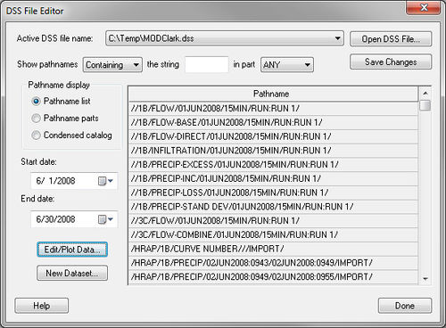
The DSS File Editor is used to view and edit a DSS file. This dialog comes up when reading a DSS file from the XY Series Editor or from the Open command in the File menu:
The following gives a description of the functionality of the DSS File Editor.
"Active DSS file name" combo box
This combo box displays a list of DSS file names that were selected using the Open DSS File button.
"Open DSS File" button
This command brings up the file browser dialog to open the DSS file. If a DSS file is selected, that DSS file (with its path) shows up in the Active DSS file name combo box and it becomes the active DSS file. A listing of the pathnames in this file is shown in the pathname spreadsheet.
"Save Changes" button
This button saves any changes made to the active DSS file.
"Show pathnames with the string" options
Remember that a single DSS file can have several pathnames, and that each pathname is broken up into six parts—A, B, C, D, E, and F. Since there can be hundreds of pathnames in a DSS file, it is useful to be able to search for text in the pathnames. That’s what these options are for.
The edit field starts out with nothing in it. As the user types something in it, only those pathnames containing what has been typed are displayed. The search is case insensitive.
"Pathname display" group box
This radio group has options for different ways of displaying the pathname. The default will be the Pathname list option. This just displays the pathnames normally, with the “/” in between different parts. If the Pathname parts option is selected, WMS displays each part of the pathnames separately. The Condensed catalog option condenses the dates for different pathnames into a single pathname.
Edit/Plot Data button
This button brings up the data from the DSS file for the selected pathname in the XY Series Editor which allows editing and plotting the data.
New Dataset button
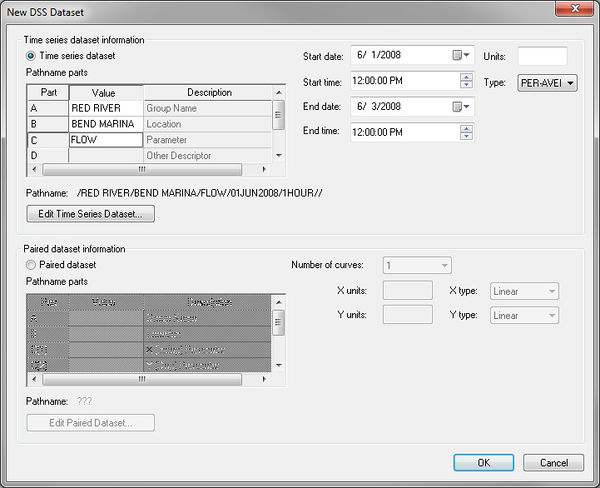
This button brings up the New DSS Dataset dialog which allows entering the pathname and other information for a new dataset:
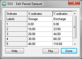
Selecting the Edit Time Series Dataset button brings up the XY Series editor, allowing the user to edit the time series dataset. Selecting the Edit Paired Dataset button brings up a spreadsheet (see below). The first editable column on this spreadsheet contains X values and the second, third, and other columns will contain Y data (Y-1, Y-2, Y-3, ) up to the number of curves specified in the combo box in the New DSS Dataset dialog.
Pathname Spreadsheet
The "pathname" spreadsheet (in the DSS File Editor dialog) lists the pathnames of all the records in the active DSS file, based on the Pathname display options.
Related Topics
WMS – Watershed Modeling System | ||
|---|---|---|
| Modules: | Terrain Data • Drainage • Map • Hydrologic Modeling • River • GIS • 2D Grid • 2D Scatter |  |
| Models: | CE-QUAL-W2 • GSSHA • HEC-1 • HEC-HMS • HEC-RAS • HSPF • MODRAT • NSS • OC Hydrograph • OC Rational • Rational • River Tools • Storm Drain • SMPDBK • SWMM • TR-20 • TR-55 | |
| Toolbars: | Modules • Macros • Units • Digitize • Static Tools • Dynamic Tools • Drawing • Get Data Tools | |
| Aquaveo | ||


