WMS:Define Upstream Channel: Difference between revisions
(→Help) |
(→Help) |
||
| (One intermediate revision by the same user not shown) | |||
| Line 7: | Line 7: | ||
This dialog functions similar to the step in which the tailwater channel was defined. When an arc is defined (arcs must be created from upstream to downstream) from this step in the wizard, their attribute is set to the HY-8 upstream arc attribute type. This arc is used when delineating the floodplain from the culvert headwater data in the next step of the wizard. | This dialog functions similar to the step in which the tailwater channel was defined. When an arc is defined (arcs must be created from upstream to downstream) from this step in the wizard, their attribute is set to the HY-8 upstream arc attribute type. This arc is used when delineating the floodplain from the culvert headwater data in the next step of the wizard. | ||
Define upstream centerline – This button allows creating arcs that represent the | Define upstream centerline – This button allows creating arcs that represent the upstream centerline. | ||
Select upstream centerline – This button allows selecting arcs that represent the | Select upstream centerline – This button allows selecting arcs that represent the upstream centerline. | ||
Delete upstream centerline – By selecting this and then clicking on an arc to delete an upstream centerline. | |||
Latest revision as of 19:52, 4 May 2020
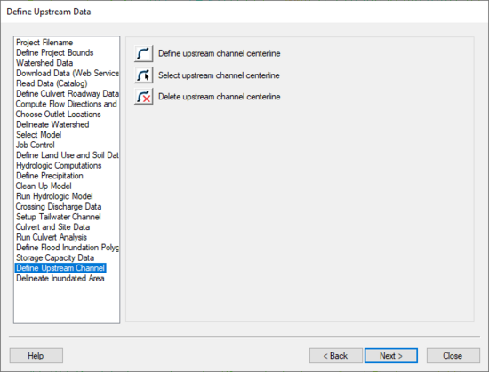
The Define Upstream Channel step is used to define an arc representing the upstream channel.
Help
This dialog functions similar to the step in which the tailwater channel was defined. When an arc is defined (arcs must be created from upstream to downstream) from this step in the wizard, their attribute is set to the HY-8 upstream arc attribute type. This arc is used when delineating the floodplain from the culvert headwater data in the next step of the wizard.
Define upstream centerline – This button allows creating arcs that represent the upstream centerline.
Select upstream centerline – This button allows selecting arcs that represent the upstream centerline.
Delete upstream centerline – By selecting this and then clicking on an arc to delete an upstream centerline.
HY8 Modeling Wizard Steps: Project Filename · Define Project Bounds · Watershed Data · Download Data (Web Service Client) · Read Data (Catalog) · Define Culvert Roadway Data · Compute Flow Directions and Flow Accumulations · Choose Outlet Locations · Delineate Watershed · Select Model · Job Control · Define Land Use and Soil Data · Hydrologic Computations · Define Precipitation · Clean Up Model · Run Hydrologic Model · Crossing Discharge Data · Setup Tailwater Channel · Culvert and Site Data · Run Culvert Analysis · Define Flood Inundation Polygon · Storage Capacity Data · Define Upstream Channel · Delineate Inundated Area
WMS – Watershed Modeling System | ||
|---|---|---|
| Modules: | Terrain Data • Drainage • Map • Hydrologic Modeling • River • GIS • 2D Grid • 2D Scatter |  |
| Models: | CE-QUAL-W2 • GSSHA • HEC-1 • HEC-HMS • HEC-RAS • HSPF • MODRAT • NSS • OC Hydrograph • OC Rational • Rational • River Tools • Storm Drain • SMPDBK • SWMM • TR-20 • TR-55 | |
| Toolbars: | Modules • Macros • Units • Digitize • Static Tools • Dynamic Tools • Drawing • Get Data Tools | |
| Aquaveo | ||
