WMS:Digitize Toolbar
From XMS Wiki
Jump to navigationJump to search
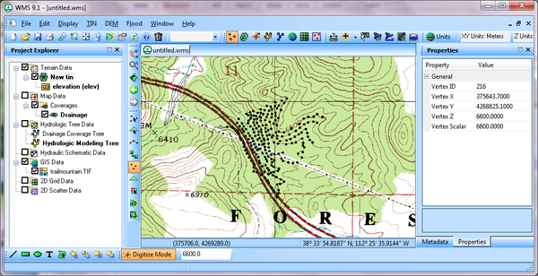
The WMS Digitize Toolbar provides a quick way to create TIN vertices if there are known elevations and there is no source of accurate elevation data other than a digital map.
For example, if there is an image of a contour map with known contour elevations, a user can turn on the Digitize Toolbar and then turn on Digitize Mode. Define an elevation value and then click on points along the contour to define vertices on a TIN, as shown below.
Once all the vertices have been defined on the TIN, a user can turn off the digitize mode and triangulate the TIN to use the TIN in the hydrologic or hydraulic model.
Related Topics
WMS – Watershed Modeling System | ||
|---|---|---|
| Modules: | Terrain Data • Drainage • Map • Hydrologic Modeling • River • GIS • 2D Grid • 2D Scatter |  |
| Models: | CE-QUAL-W2 • GSSHA • HEC-1 • HEC-HMS • HEC-RAS • HSPF • MODRAT • NSS • OC Hydrograph • OC Rational • Rational • River Tools • Storm Drain • SMPDBK • SWMM • TR-20 • TR-55 | |
| Toolbars: | Modules • Macros • Units • Digitize • Static Tools • Dynamic Tools • Drawing • Get Data Tools | |
| Aquaveo | ||
